Thursday, August 27, 2015

Winter in Alaska

Please welcome guest commentator, David Staat…

While on our trip to Alaska this year, I received an email from a good friend of mine. He asked, "When does winter start in Alaska?"  Very good question, and one I hadn't contemplated much.

I have found that the winter season and/or preparation for it drives much of the activities in Alaska. Storing up food and heating materials for the long cold months, completing home projects, roadwork activity, and migration for seasonal workers, tourists and wildlife… even how much partying and outdoor activities the Alaskans participate in during the "non winter" months. 

It is a good question, and I have heard many comments about the start of winter as we travel through this great and beautiful state. So, I think this subject warrants a blog post.

Here are some of the responses I have received to date from both native Alaskans to the more recent Alaska immigrants. So here goes…

When is it winter in Alaska?

· October… that is when the bears start to hibernate.
· When the caribou start showing up during migration (this is around the Arctic Circle), any time between late August and mid September. 
· When we start getting sustained freezing temperatures... about mid November... of course that depends on the elevation and latitude.
· When the leaves start turning... which could be any time from late August to September.
When road construction stops for the year, which is normally September.
· When the birds flock up and start to fly south... late August and early September.
· When the people who don't live here year round start heading south.
· When it is time to put on the snow tires.
· When it is required to have chains on your vehicle to travel some roads, which is from October 1 to April 1.
· When moose or caribou hunting season opens in early August.
· The official start of winter... like the Lower 48... which is December 21.
· When the ice roads open which is mid to late January.
· When the whales head south to warmer waters to give birth.
· Whenever it snows, which means winter could be any time of year.
· And my favorite to date is: "There are two seasons in Alaska, July and winter."

For us, winter comes to Alaska when my wife is wearing every stitch if clothing we brought along for our trip.

So I guess the answer to the question "When does winter come to Alaska?" depends on the time of year you pose the question and who you talk to.  Then again, I guess that is true of any place you travel.  Thanks for the question, Glenn!

So when does winter come to your neck of the woods? Leave us a comment, we would love to hear from you.

Wednesday, August 26, 2015

Eagle, Alaska

Eagle, Alaska from Yukon River
Our first visit to Eagle, Alaska, was during last year’s (2014) trip.  This small town at the top of the world has become one of our favorite towns in Alaska.  The people are warm and friendly, the scenery picturesque, and it is far from the tourist crowd.  We stay at the BLM campground, nestled deep in the forest of pines and tundra.  The campground averages three campers per day this year, up from just two last year. 

Eagle now boasts a restaurant, compliments of the Eagle Trading Company’s new venture to add 48 motel rooms, a general store, and restaurant.  During the 2009 flood, the restaurant and original ten-room motel washed away.  Although the motel was not yet open, the restaurant served a fine breakfast with quality food and good prices for such a remote area.  The new motel will join the Falcon Inn B&B as places to stay in Eagle.


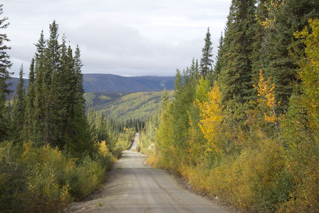
The town of Eagle rests at the end of the Taylor Highway, some 161 from the Alaska Highway and 94 miles north of Chicken, Alaska.  The road between Chicken and Eagle is entirely gravel, passable with two-wheel drive, and seems well maintained.  With beautiful scenery the entire route, the Taylor Highway winds through some high ridge roads and down through deep canyons.  Some areas have tight curves with steep cliffs on one side and drop offs on the other, which can be particularly intimidating to some, particularly those driving large rigs.  Between mid-October and April, the road to Eagle is closed and the town is accessible only by plane.

View from Taylor Highway, Alaska
Rim road on Taylor Highway, Alaska
Eagle includes about 100 residents, most of them full timers (those who stay all year long).  The new community school has 21 children enrolled this year.  The town is powered by a community generator.  It also has a community well where most folks fill great water holding tanks since few of the houses have running water. 

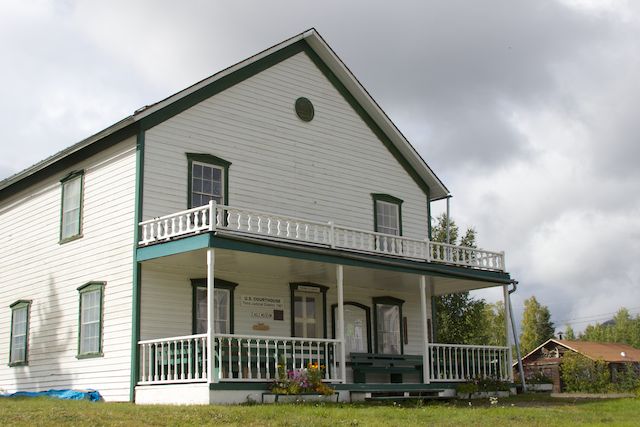
Courthouse, Eagle, Alaska

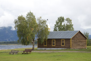
Restored church overlooking Yukon River, Eagle, Alaska
We arrived in Eagle on a Saturday so were able to join worship service at the Eagle Bible Chapel on Sunday morning.  We were so surprised to be greeted by their wonderful band playing praise music as folks mingled until service began.  The band included a flute, trumpet, mandolin, piano, bass guitar, and three acoustic guitars.  They played old hymns that I grew up with as a child.  I admit when they played In the Garden, it was hard to hold back tears.  We have sung that hymn at almost all of our immediate family funerals.

The church had about 30 worshipers this day.  After the service, many stopped to chat with us, including Steven, the gentleman who gave us our tour of Eagle’s museum and Fort Egbert last year.  It felt like we were coming home… the rare gift of a small town.  How wonderful!

After church, we visited the new Eagle Trading Company restaurant for breakfast and were allowed to peek into several of the yet unfinished motel rooms.  These rooms will probably be open to guests next year.  Then we drove out to the Han tribal community, several miles out of town.  The original tribal settlement had been demolished during the flood of May 2009.  It was completely rebuilt on higher ground with the help of both Mennonite and Billy Graham-backed relief efforts. 

Monday, after a visit to the Yukon-Charley Rivers National Preserve Visitor Center and some pointers from Ranger Chris on gold panning, we decided to try our luck panning on Jack Wade Creek, just down the road from our campground.  This section of water is open to anyone to pan for gold (unless there is evidence of mining equipment in the area).  I decided quickly that I never would have made it during the gold rush… the water was too cold, quickly numbing fingers, and the pickings too slim.  We certainly didn’t find that life-changing nugget while sifting through the silt!


Last year the campground was covered in a wide variety of wild mushrooms that we had never before seen.  It had been drier this year, so the proliferation of mushrooms was much less.  The rain, however, caught up with us yet again.  By the time we departed, more mushrooms began to pop up in the moss-covered, spongy tundra, including the rare bleeding mushroom.


In the afternoon we took the Pipeline Trail, which meanders from the campground along Fort Egbert’s original water pipeline.  The pipeline provided water to the fort from a small stream near the creek.  A boiler house pumped the water uphill while warming houses kept the water from freezing. 


 The trail ended on top of the small, grass runway that overlooks the Visitor Center and the Yukon River.  We both looked up, laughing, remembering last year’s experience.  The runway landing is right over the road to the campground, complete with cautionary signs. 

View from end of Pipeline Trail, Eagle, Alaska

Last year as we were strolling along Fort Egbert’s historic grounds, we both instinctively ducked as a small blue plane came in low and sideways over the hill, attempting to make a landing amidst a fierce crosswind on this short field.  At first it seemed as if he wouldn’t make it.  The plane looked catywampus and in dire need of altitude.  His touchdown, however, was perfect… a testament to a true Alaskan bush pilot … his years of experience obvious.  We have since learned that the pilot is over 80 years old and has been flying since he could walk.  Here is a photo from last year’s adventure to give you an idea of his approach…

An Alaska bush pilot lands in Eagle... road to campground in extreme lower-right corner!
Fall colors have begun to bathe the mountainsides, becoming more and more brilliant each day.  We awoke to sunshine and bid a fond farewell to Eagle and its wonderful townspeople, vowing to return.  Today, however, the Dempster beckons, and we must go!

Taylor Highway, Alaska


Saturday, August 22, 2015

The Nabesna Road

Wrangell-St. Elias National Park
Wrangell-St. Elias National Park in Alaska is the largest park in the nation, covering 13.2 million acres.  It has extremely limited access, with only two major roads.  One lies to the south, the McCarthy Road, and the second road lies on the northern side of the Wrangell mountain range.  This is the Nabesna Road, 42 miles of rough gravel, including at least five water crossings.  A high-clearance (preferably 4-wheel-drive in wet weather) vehicle is necessary for the last ten miles.

We traversed the Nabesna during our 2010 trip.  At that time, the park was building a primitive (dry) campground but it was not yet complete.  We stopped at the Salana Ranger station, located at the beginning of the Nabesna Road to check road conditions.  Dark clouds hovered over the mountains.  The park ranger told us that with all the rain that some of the water crossings may be high but should retreat quite quickly once the rain passed.  Another ranger told us that the postal driver had turned back earlier in the afternoon at the third crossing because it was too high.

We traveled as far as the same crossing.  The water rushed through the gulley in a torrent.  Not knowing how deep it might be, we retreated to the now-completed campground for the evening.  The campground was nestled in the pines and provided a quite and beautiful spot for the night. 

The following morning, we broke camp and decided to try the water crossings again.  To our delight, the water had gone down substantially.  We decided to ford and travel to the end of the road to the now defunct and historical Nabesna gold mine.  

Water crossing on Nabesna Road
The mountains before us boasted a fresh dusting of snow.  In the distance, we spied mountain goats.


The town of Nebesna rests near the end of the road.  It has maybe a dozen houses, a bed and breakfast, an outdoor adventure guide, a few small planes, and a grass runway.  The road narrows substantially after the town and dead-ends at a “road closed” sign.  About 3-1/2 miles up this road rests the ruins of the Nabesna gold mine.  


We decided to stroll up the road.  About a half-mile in, we discovered a trail to the Rambler Mine.  We could see the water flume from the road but dared not try to take the trail.  Although it was under a mile in length, the trail climbed over 400 feet in altitude.  Our Golden girl’s legs were already trembling.  We decided it best to hike back to the truck. 


As Roxanne snored softly in the backseat, we returned back down the Nabesna Road, past our last night’s camp.  We decided to stay in one of the camping pullouts nearer the entrance for an early morning start to Tok since we had several errands to finish before leaving Alaska.  It was a beautiful campsite, overlooking Rock Lake and Mt. Wrangell.  Because it was a bit buggy in the sun, we put up the screened tent to ward off those nasty gnats.


Evening began to settle in, and the mountain range had only wisps of clouds surrounding it, promising a glorious morning.  Suddenly a car pulled into the camp and two men barreled out.  They didn’t bother saying anything to us, just went to a high spot and began to peer over the lake.  David met them.  They said, “Oh, sorry to bother you, we’re hunters.”

Seems that it was the first day of moose season for subsistence hunters in the area.  A large bull moose had his territory around Rock Lake, and these fellows were trying to locate him.  By the end of the evening, no less than seven vehicles stopped to look for this same moose.  (Obviously our choice of campsites was the envy of everyone.)  David would get out of the camper and explain to each one that we hadn’t seen the moose.  All of the hunters seemed nice, but it was still quite disconcerting to have so many pull into our one-spot camp.  We were grateful when night fell but knew that morning would bring a similar parade of vehicles.

Sunset on Mt. Wrangell
It was as if the Spirit nudged me the next morning.  Most of you know that I am not an early riser.  But I woke and rolled to look at Wrangell Mountain.  I quickly grabbed my glasses to make certain that what I thought I saw was what I saw… the mountain bathed in red.  As I slid out of bed, a bewildered David asked, “What are you doing?”

“Look at the mountain,” I said.  “I’m taking photos.”

Sunrise on Mt. Wrangell
He, too, scrambled out of bed.  We spent the next hour in the morning chill, drinking in the beauty before us.  Wow!


With even the lower mountains dusted in snow and fall colors showing more and more each day, we knew what we needed to do.  Our battle cry now seems to be, “We’ve got to get up the Dempster!” 

We broke camp, drove to Tok, then on to Chicken.  After taking showers, we traveled on to Walker Creek Campground on the Taylor Highway.  Tomorrow we return to Eagle, then will leave Alaska for our final northern goal… Canada’s Dempster Highway.