
Monday, October 5, 2015
Sunday, October 4, 2015
Staat Stats 2015
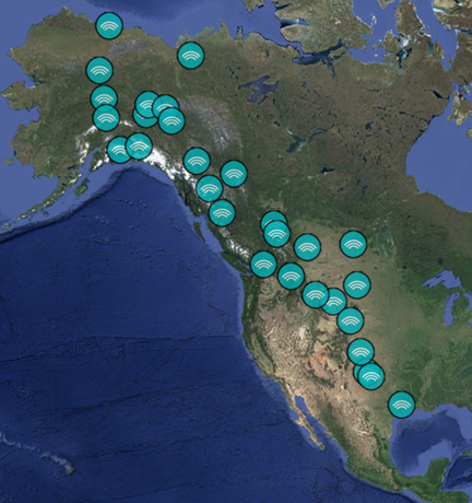 |
| 2015 Trip Map |
To summarize our 2015 adventure, here are a few Staat Stats:
Miles travelled: 16,240
Miles travelled on gravel roads (including 4-wheel drive roads): 2,744 (mas or menos)
Days on the road: 84
Days in Alaska: 38
Days in Canada: 32
Days in Lower 48: 14
Days in Alaska: 38
Days in Canada: 32
Days in Lower 48: 14
States visited: 8
Canadian Provinces visited: 3
Canadian Territories visited: 1
Most expensive gasoline: $5.79 per gallon (Canadian dollars)
Nights in Motels: 4
And... drum roll, please... since we began these trips in 2010, we have traveled...
Sum total of miles: 92,478 miles
Sum total of days on the road: 499
WOW!!!
Nights in Motels: 4
And... drum roll, please... since we began these trips in 2010, we have traveled...
Sum total of miles: 92,478 miles
Sum total of days on the road: 499
WOW!!!
Saturday, October 3, 2015
Why Me, Lord?

On this year's trip, while we sat at the Wolf's Den, a Swiss restaurant located in Whitehorse and Canada's Yukon, it pleased me that they were playing country legends on their radio. Then Kris Kristofferson's song Why Me, Lord began to play, and I had difficulty holding back tears.
We had just come off my favorite highway, the Dempster, with all its animals, snow, mud, and drama. The song's words floated between David and me, and all we could do was look at each other and smile... What have I ever done to deserve even one of the pleasures I've known?
Now that we're back in Texas and I sit in the comfort of our lovely home, I find myself still humming the tune. I've been thinking about how privileged David and I are. We have seen so many wonders! I'm hoping that you might enjoy reading about just a few of the amazing things we have witnessed and experienced... in nature alone. (Perhaps you'd be willing to share some of your experiences, too, in the comments section below.) Here goes...
- One moonless night at the bottom of Palo Duro Canyon, we laid upon the rooftop of our SUV and watched thousands of shooting stars flash across the sky during a meteor shower.
- We have caught our breath at the top of two fourteeners surveying vistas that seemed to touch the very face of God.
- During a night at Wood Buffalo, we stood awestruck in parkas and pajamas, watching the sky radiate with amazing northern lights.
- After a hike up Hermosa Peak, we literally witnessed a mountain breathe beneath its coat of many colors.
- One night while on the Mississippi Sound, we sailed along a moonlight trail that led us to a moment in paradise.
- We have stood in the Badlands while a white and wild stallion pranced his way into our hearts.
- On the shores of the Bay of Fundy, we watched 30,000 sandpipers dance a dazzling folk ballet between sea and sky.
- We have showered with bison, bedded with elk, cradled a hawk, walked unknowingly into a herd of javelina, ridden on horseback past feeding mountain lions, and been chased by a mother mountain sheep.
- We have camped during earthquakes, hurricanes, snow, fire, torrential rain, and had lightening strike the tree we slept next to.
- We have witnessed glaciers calving, bears fishing, cranes dancing, otter playing, eagles landing, seals swimming, birds nesting, wild stallions fighting, bison rolling, sea stars clinging, moose sunbathing, gannets hovering, spiders weaving, coyote hunting, elk sparring, ravens stealing, whales spouting, sunsets fading, geese flying, bats hanging, gulls squawking, dolphins jumping, squirrels chattering, tidal pools brimming, puffins tumbling, rainbows arching, skunks spraying, mushrooms bleeding, lizards scurrying, antelope sprinting, prairie dogs jump-yipping, aspen quaking, stars falling, sand pipers swooping, marmots whistling, ice melting, salmon spawning, deer bounding, snakes slithering, swans gliding, snow drifting, wildflowers blooming, waves crashing, butterflies hatching, and a luna moth dying.
- Whales have waved at us, grizzlies have gazed at us, hummingbirds have dive-bombed us, muskox have stared at us, snakes have struck at us, wild horses have laughed at us, an enormous sea turtle swam with us, and once a wolf sat behind our camper and surveyed us with soft and endearing eyes.
- We have heard loons call, coyotes sing, elks bugle, bears growl, bison grunt, rabbits shriek, wild horses whinny, owls hoot, caribous snort, mountain sheep baa, bees buzz, seals bark, wolves howl, wild donkeys bray, and eagles scream.
- And this year, we watched a Blood Moon disappear during a total eclipse and witnessed the very skies declare His Glory.
Thank you from the bottom of my heart, Dear Jesus. I can't wait to see what happens next!
Why me Lord, what have I ever done
To deserve even one of the pleasures I've known?
Tell me Lord, what did I ever do
That was worth loving' You or the kindness You've shown?
Lord help me, Jesus, I've wasted it so
Help me Jesus, I know what I am.
But now that I know that I've needed You so
Help me, Jesus, my soul's in Your hand.
Try me, Lord, if You think there's a way
I can try to repay all I've taken from You.
Maybe Lord, I can show someone else
What I go through myself, on my way back to You.
Lord help me, Jesus, I've wasted it so
Help me, Jesus, I know what I am.
But now that I know that I've needed You so
Help me, Jesus, my soul's in Your hand.
Jesus, my soul's in Your hand.
Singer/songwriter: Kris Kristofferson
Monday, September 28, 2015
Amazing but TRUE!!!
 |
| Windmill near equestrian campground Caprock Canyon State Park, Texas |
Rather than staying in South Dakota, we traveled on toward Texas, stopping at the John Martin Reservoir campground near Hasty, Colorado. We were new to this campground. The park had great facilities, spread out campsites, and lots of lovely cottonwoods.
The next morning, we crossed the Texas state line and continued driving to what has often become our favorite final stay of these adventures... Caprock Canyon State Park, just south of Amarillo. Our favorite camp spot is on a low bluff in the overflow camping area. Last year's trip ending had been so special here. A coyote had hunted just beyond our camper... Deer grazed under the setting sun... The night sky was spectacular.
We set up camp and had a bite to eat. Then we sat in our camp chairs, facing east, enjoying the cool breeze, and talking about our many adventures during this trip. I had my camera with the long-range lens resting in my lap, waiting for another coyote to show. None came... not even a deer.
I was disappointed, but then a beautiful full and red moon peaked over the horizon. It was too wonderful not to take a few photos.
 |
| Blood Moon at sunset, Caprock Canyon State Park, Texas |
The full moon continued to rise. At next glance, however, David and I noticed that it wasn't quite full anymore. Perhaps we were mistaken and it needed another day or two... or could this, in fact, be the eclipse? We pulled out tripods just in case.
The following several hours were beyond extraordinary. Unbeknownst to us, we had arrived in Caprock Canyon just in time for front row seats to a total Blood Moon eclipse! Later we discovered that the last time a harvest moon eclipsed was in 1982... the next won't occur until 2033. God's generosity never ceases to amaze me!
 |
| Beginning of Blood Moon eclipse |
 |
| First quarter |
 |
| Nearly half |
 |
| Half moon eclipse |
 |
| Full eclipse of the Blood Moon |
Coincidence? I think not...
When the eclipse was full and the super moon darkened in crimson hues, the night sky was so filled with stars that it took our breath away. Shooting stars arched across the sky as the blood moon hid behind the earth's shadow... and the skies declared His Glory. And how glorious God is, indeed!
The heavens declare the glory of God,
and the sky displays what His Hands have made. (Psalm 19:1)
Sunday, September 27, 2015
In Search of a White Stallion
 |
| Gray Ghost in 2010 |
Earlier this year, I saw a post from a group that monitors the wild horses here in TRNP that Gray Ghost lost his band this spring when two brother bachelor stallions fought him and won. One of the victorious stallions then drove his brother from the band. The group reported that Gray Ghost was again badly injured and alone. We had heard nothing about the stallion since early spring. We came to TRNP this year to find him.
The South Unit is over 46,000 acres in size, much of it accessible only by foot or horseback. With Roxanne in tow (dogs are not allowed on national park trails), we knew that locating this stallion would be like finding a needle in a haystack. Hope, however, springs eternal.
After our many visits to TRNP, we have grown fond of several bands within the park. On our first tour around the 26-mile wildlife loop that evening, we were happy to find the black stallion and his band. He had obviously had a grand time rolling in the mud.


We also saw bison, deer, and a coyote running so close to the road that I couldn't capture all of him in the frame because I was using my long-range lens.


We knew that Gray Ghost's former territory had been near the Coal Vein hiking trail. To our chagrin, we discovered the gravel road to Coal Vein closed. A park ranger informed us that the enormous amount of rain they had received this spring washed the road out. Not even foot traffic was allowed on it.
The following morning, we found Cloud and his band in the Skyline prairie dog town.

The bison were just coming out of rut. We witnessed several grunting bouts but no fights.

Day three, and still no white stallion. We awoke to find Cloud and his band grazing right through the campground. Then, during our morning jaunt around the wildlife loop, we spied a band in Grey Ghost's old territory. I recognized the boss mare. It was Grey Ghost's old band, now led by the wretched stallion who, with help from his brother, won the band.

On the evening wildlife loop tour, we saw turkeys, more prairie dogs, and the stallion known as Silver and his boss mare.


While temperatures were mild during the day, it was still too warm to leave Roxanne in the car most of the time. We awoke early our fourth morning to temperatures in the low 50s... cool enough to leave Rox to hike up the Ridgeline trail. We found a lovely cottonwood in color and in the distance a gray stallion with a band, but not my white stallion.

Feeling thwarted, we decided to hike up Buck Hill. We had been hiking the south bluff next to Buck Hill because it was closer to Coal Vein and had a great vantage point to view the area. The more northern Buck Hill overlooks less of the Coal Vein area but is a bit higher.
Once on top, David did a thorough search with his binoculars, while I peered through my long-range lens to survey the area. Then I spied a white dot on a distant bluff. I called to David, and he confirmed... it was a white horse. Using David's shoulder to steady the camera, we counted to three, then both of us held our breath. I took a shot, then used David to shadow the LED display. I blew up the photo as much as possible. Without a doubt... we had found him!
Once on top, David did a thorough search with his binoculars, while I peered through my long-range lens to survey the area. Then I spied a white dot on a distant bluff. I called to David, and he confirmed... it was a white horse. Using David's shoulder to steady the camera, we counted to three, then both of us held our breath. I took a shot, then used David to shadow the LED display. I blew up the photo as much as possible. Without a doubt... we had found him!


Not only did we locate Gray Ghost, but he had a light grey horse with him. We later learned that it is another bachelor stallion. Although it was difficult to tell from such a great distance, Grey Ghost looked healthy. Glory be... we had found my white stallion!
It was easy to change focus now and take in the beauty of TRNP. When greeted by another chilly morning, we took a hike up Wind Canyon.
 |
| View from Wind Canyon, Theodore Roosevelt National Park |
 |
| Cottonwood Creek, Theodore National Park, South Unit |
Over the next several days, we climbed Buck Hill each morning. Each time we were able to see my white stallion grazing in the far distance. On our final full day at TRNP, we also found the stallion we affectionately call Big Red, the last horse that I needed to see for this visit to feel complete.

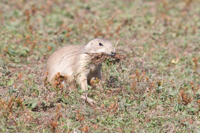
Another close encounter with a coyote... a prairie dog gathering grass for the upcoming winter... more beautiful scenery... more wild horses.


Our last evening at TRNP, we sat overlooking Cottonwood Creek, enjoying a beautiful sunset, warm weather, and blue skies. It was yet another wonderful ending to a fantastic trip... I love this park!

Sunday, September 20, 2015
What a Difference Two Years Makes!
 |
| Theodore Roosevelt National Park, North Unit |
My, oh my, have things changed in North Dakota! Since we were last here, the tiny town of Williston has become an oil boom town, doubling in size (from just over 14,000 folks to nearly 27,000). Traffic was bumper to bumper, cars buzzed past us, heavy trucks rumbled around us, and construction was everywhere. After all our remoteness, we were feeling like pilgrims in an unholy land.
We had also failed to recognize until we were half-way through town that we had arrived on a Friday afternoon, essentially during rush hour. Knowing that the state park was on a lake, we decided it would be chocker-block full of folks for the weekend. Figuring that Theodore Roosevelt's North Unit would be less of a draw for weekenders, we decided to drive the additional 60 miles. Thankfully, within about 30 miles, the boom town and most of the drilling support were behind us and the landscape returned to familiar farms, ranches, grasslands, and Badlands.
We arrived at TRNP's North Unit at dusk... and under cloudless skies. Settling into our campsite, we began drying out, hanging wet towels, rain gear, and Roxanne's bedding from every available outside hook and flat surface. We sat out in the cool breeze under the stars and breathed a great sigh of relief. We were back in the States, the weather was warm and dry... we were definitely happy campers!
The next morning, we took the 14-mile tour on the park road. As usual, TRNP didn't disappoint. We spied deer, bison, prairie dogs, and lovely vistas.


On our way back down the park road, we stopped to view a herd of big horn sheep in the distance. Park Ranger John was peering through binoculars, counting the sheep as I set up my tripod. He told us that the sheep had become infected with a deadly strain of pneumonia brought on by contact with domestic sheep. So far 30-40 percent of the state's big horn sheep population have died as a result of the pneumonia outbreak. While hiking in the park, he had recently found a mature ram dead from the infection.
 |
| Big horn sheep at Theodore Roosevelt National Park North Unit |
We meandered out of the park. Change had certainly become a reoccurring theme during this year's adventure. Our next stop was TRNP's South Unit and my wild horses. We have not been to the park since the last horse roundup which dropped the herd population from about 170 to 88 mature horses. How much has the South Unit changed? We knew there was only one way to find out... we turned southbound on Highway 85.
Saturday, September 19, 2015
Southbound
We crawled inside the camper for dinner and decided to leave the next morning. Our plans were to enter the States in Montana, then head towards Theodore Roosevelt National Park. Within minutes of making the decision, the pitter patter of rain stopped.
We stepped outside as the remaining clouds dissipated. The sun came out, and we witnessed a glorious sunset.


The next morning, as we drove out of town, we spied a thousands of snow geese circling. Sometimes God's generosity overwhelms me. These birds were circling to land and glean a farmer's field right off the highway. Of course, we stopped for photos!


We stopped in Regina for a car wash and gasoline, spending the last of our Canadian dollars during the fill up. The border crossing was easy as pie.
It always surprises me how wonderful it is to have speed limit signs in miles again rather than kilometers. We're back in the good ole' U.S. of A. Life is GOOD!
Friday, September 18, 2015
The Unexpected Story
 |
| A duck swims on Quill Lake alongside Grid Road 640 |
The Quill Lakes are a series of lakes in southeastern
Saskatchewan. Known as the Quills by
locals, these lakes are considered extraordinary because of their high saline
concentration. In the 1950s, Big Quill
Lake was three times more salty than an ocean.
This unique ecosystem in the midst of mixed grasslands is perfect for
migrating waterfowl.
During the spring and fall, nearly a million waterfowl visit
the Quills. This high concentration of water birds includes over 400,000 ducks,
130,000 snow geese, 80,000 Canada geese, 40,000 sandhill cranes, and 200,000
other kinds of shorebirds, including the rare piping plover. We came to the Quills to photograph these birds. I envisioned framing a blast-off, capturing
the moment when enormous numbers of snow geese fly out simultaneously for a day
of gleaning fields. I longed to hear the
thunder of their wings.
We did not find the concentration of waterfowl we expected
at the Quills. Instead we found an unexpected story and a community in crisis. Kyle, our guide at the
Wynyard Waterfowl Interpretive Center led us to a map showing Big Quill, Little
Quill, and Mud Lakes and told us that the map was no longer accurate. Because of extensive flooding since 2004,
these lakes have merged into one large lake. He explained the flooding has been exacerbated
because the Quills are a closed-basin system.
This means that during floods water runs in but does not run out,
causing water to spread out rapidly within the basin.
As a result of the flooding, mudflats and marshland have
been absorbed by the lakes, compromising feeding and nesting grounds. Nature trails and observation decks are now
underwater. We learned that migratory
waterfowl concentrations have become more spread out and fewer birds frequent
the area. He said that no one knows
where nesting piping plovers have gone.
Kyle told us that snow geese began arriving several
weeks earlier and suggested we may be able to photograph some along Grid Road
640.
He told us that we would encounter road closure signs but they were mostly
to discourage commercial vehicles. We
decided to take the drive to see what we could see.
Grid Road 640 is a 22-mile-long gravel road connecting
Wynyard to the Village of Quill Lake. At one time the road ran between the lakes, with Big Quill Lake on the western side of the road and Mud and Little Quill Lakes on the eastern side. Shortly
after we passed the road closure signs, we recognized that because of the
flooding the road had become a dike, essentially separating the now-one lake into two
sections. The wave action along the road
had deeply eroded its sides.
 |
| Fence rows barely visible in Quill Lake flooding |
As we drove, we encountered fence rows barely visible above
the water. Houses and barns were
diked. Farm equipment, as well as Canada geese, were stacked on
small islands. Ducks and coots swam
inches from the edge of the road.


A barricade with heavy concrete partitions crisscrossed the Grid 640 bridge. Weaving through the maze, we could see water lapping at the top of the bridge. The boards beneath us creaked and groaned as we crossed. The further we drove toward the Village of Quill Lake, the more the water encroached around us.
 |
| Barricade on Grid Road 640 |
With few waterfowl in the area, we turned around and crossed the bridge again, slowing to a
stop to take photos. A man in a pickup hailed us and rolled down his window.
Lyle Thibault, a Quill Lake councilman and life-long resident of the area, had noticed our Texas tags and
was kind enough to stop to chat.
I told him, “You’ve got a huge problem here, Sir.”
He agreed and began telling us the Quill Lake story. “This is a not a 500-year flood. This is a 2,000-year event that we are
dealing with here.”
Mr. Thibault explained that during the past ten years,
excessive rainfall had caused the lakes to rise over 21 feet. As a result, 27,000 crop acres and 56,000
acres of pastureland were flooded. In the process, livelihoods and generational farms have been lost.
He lamented that the floods have changed everything. The environmental impact has been devastating. Many birds have stopped nesting or migrating to the area. Once these were considered to be dead lakes because of their excessive salinity. Now because the road is a dike between two halves of the lake, there is little mixing of the eastern side of the flood waters with the western side. As a result, the eastern side of Quill Lake has become so washed with fresh water that it can support freshwater fish like the walleye.
He lamented that the floods have changed everything. The environmental impact has been devastating. Many birds have stopped nesting or migrating to the area. Once these were considered to be dead lakes because of their excessive salinity. Now because the road is a dike between two halves of the lake, there is little mixing of the eastern side of the flood waters with the western side. As a result, the eastern side of Quill Lake has become so washed with fresh water that it can support freshwater fish like the walleye.
He told us that the road we were driving has been raised
over three feet and reinforced with rock ballast along the sides to prevent
further erosion. Within the past week, the
community finished a project to install barricades and a concrete maze across
the bridge to prevent commercial traffic from further damaging the
structure. The bridge remains critical
to the road’s integrity and accessibility between the two towns. If it fails, the twenty-minute drive between
Wynyard and Quill Lakes will become over an hour long as drivers detour around. Thankfully, a portable bridge has been found
that will be placed over the top of the existing bridge within the next few
weeks. If excessive rain continues,
however, Grid Road 640, Highways 16 and 6, and a portion of the Canada Pacific
railway line may become impassable.
Mr. Thibault voiced concerns over attempts to manage the flooding. The Quill Lake basin is nearly full. Like a teacup with too much tea pouring into
it, the lake will soon begin spilling over, with much of it going to the southwest and into Last
Mountain Lake. If that happens, even more farmland, pastureland, and sensitive wetlands will be flooded along the way. Because of the salinity
of these floodwaters, fish and bird populations will be affected. Even if the water begins to recede, the salt may
permanently damage the farmland’s ability to be productive. Solutions are complex, costly, and none
satisfies every need. A dam proposal had
just been defeated. Petitions for
government assistance to displaced farmers and landowners have yet to be
approved. “It’s a catastrophic event,” Thibault
concluded.
 |
| An open gate to a field swamped by flood waters on Grid Road 640 |
We thanked Mr. Thibault for his time and wished him and his
constituents our best. Under heavy clouds and with a heavy heart, I stepped out of the
truck to take a photo of an open gate to a field swamped by flood waters. A large formation of snow geese came honking into view. As I watched them fly overhead, a misty rain began to fall.
 |
| Snow geese fly over Quill Lake |
If you would like to read more about the Quill Lake flooding, please check out these news articles...
- http://www.leaderpost.com/technology/Quill+Lakes+flooding+threat/11295125/story.html
- http://cjme.com/article/203110/salty-water-quill-lakes-flooding-farmland
Subscribe to:
Posts (Atom)