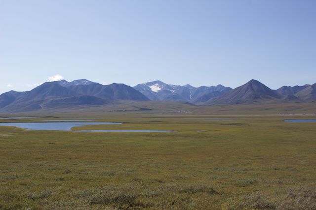
Friday, July 31, 2015

We Felt the Earth Move Under Our Feet!

Skilak Lake
In 2010 we stayed at the Upper Skilak Lake campground and enjoyed our visit so much that an overnight stay turned into five days.  We were delighted to find our campsite #13 open and immediately drove in and set camp.  Of course, Roxanne was in the water within minutes.


We pulled out Calypso, our blow-up boat, pumped her up, and took a little row along the shoreline.  Rox was cold from her swim and snuggled next to me for warmth.  (There’s nothing better than having a rather damp Golden girl snuggled next to you!)  


With storm clouds brewing, my captain decided he best row for shore.  Roxanne, however, was content to stay in the boat.


As clouds began to darken the skies even further, David made a campfire.  We were sitting on the concrete picnic bench, enjoying the warmth and chatting.  Suddenly, things began to move.  Both David and I looked at each other.  It took a few seconds for us to realize that it was an earthquake!  The ground bucked and rolled with enough strength that we grabbed one another.  While it only lasted about 30 seconds, we learned later that the quake registered 6.3, with the epicenter being under the Mt. Redoubt volcano off Cook's Inlet.  A clerk in Soldotna later told us that several items fell of her shelves at her house.  Earthquakes are not new in the area.  In southeastern Alaska alone, there have been 92 earthquakes in the past week and 364 in the past month, all greater than a 1.5 rating.  Wow!

Soon after the earthquake, the skies opened up and we were in a downpour that lasted most of the night.  Still, the gulls on their nearby island rookery squawked their raucous lullaby throughout the night.

Gull rookery on Skilak lake
With misty rain greeting us the next morning, we decided to drive to Soldotna to fill our water tank.  The visitor’s center told us that the new Fred Myers (much like a Walmart) had water and a dump station, along with free RV parking.  We waited in line for nearly a half hour to fill our small water tank.  It was amazing how much Soldotna had grown in the past five years.  The traffic was so heavy that it took several tries to get through the main stoplights.  How different the whole area felt than it had five years ago!  It was definitely no longer a sleepy little town.  We stopped by a favorite breakfast place, ran a few quick errands, then retreated back to camp.


We discovered that the campground, too, was becoming full and, unfortunately, the sites are very close together.  Grey skies also continued overhead, offering little chance for another row in Calypso.  So, we decided to break camp this morning and head to Captain Cook’s State Park on Cook’s Inlet.  We saw several moose in the area in 2010, including a cow with twin calves.  Hopefully, we will see more again this time.  I must tell you… this trigger finger of mine definitely needs a workout!


Wednesday, July 29, 2015

Parks Highway and Anchorage

We broke camp early and drove into Fairbanks for breakfast.  After that, we decided to stop by Creamer’s Field to see if the sandhill cranes had begun migrating (they had not), then we drove the Parks Highway, heading south.  Along the way, we decided to take a chance to stop by Denali National Park.  We hoped that since it was a Sunday afternoon that there might be camping spots available.  Unfortunately, there were none.  We continued on under heavy clouds and rain to Cantwell, camping at a place we had found during out 2010 trip and remembering their great showers.  It’s amazing how wonderful a hot shower can be!

The following morning we drove into Anchorage to reprovision.  Our new backpacking stove refused to ignite, so we stopped at REI to return/replace it.  Next we stopped at the grocery store and, finally, at a Laundromat.  Barbie’s Café, just around the corner, was the high spot for our day.  The entire café was decorated in various shades of purple, and Barbie, the owner, was also dressed in purple… right down to the rubberbands on her long braid.  She was a delight to talk with, offering all kinds of suggestions to such distant travelers. 

By the time we had turned and detoured our way across town, both of us were exhausted from being back in the city’s hustle and bustle, particularly after coming off the remote Dalton and Elliott highways. 

The Seward Highway leads south out of Anchorage and is always busy.  The mostly two-lane road runs along Turnagain Arm, a large bay of water, and is the only road leading to the Kenai Peninsula.  It had a steady stream of working trucks, RVs, sedans, and motorcycles.  We turned left on the Whittier/Portage Glacier access road to Bear Creek campground, which we had visited in 2010.  Again we found our favorite campsite open.  It felt good to be out of the chaos of the city and in the deep forest again. 


We three took a stroll up the trail and settled in for a peaceful evening’s rest.  It is finally beginning to get dark at night again (sunrise around 5:30 and sunset about 10:30), now that we are past July 28 and further south.  Tomorrow we drive to Skilak Lake, one of our favorite spots during our 2010 trip. 


Williwaw Creek crossing, Iceberg Trail

Tuesday, July 28, 2015

Manley Hot Springs Road / End of Elliott Highway

At the end of the Dalton Highway, we had a choice to turn left to return to Fairbanks or right to visit Manley Hot Springs.  It was another new road for us, so we chose to turn right. 

This 70-mile stretch of road began much like the end of the Dalton.  It was gravel but easily passable.  Soon, however, it turned to dips, bumps, washboards, and deep potholes.  About 35 miles in, we began to see road construction signs and stopped to wait for a pilot car.  An enormous amount of road equipment covered the area… bulldozers, scrappers, graders, water trucks, backhoes… you name it.  Evidently the road had gotten so bad in this area that crews were cutting a new section over a 13-mile stretch.  The construction area was very torn up.  Some areas were so soft that David turned on the 4x4 while I drove. 


It took us nearly 45 minutes to make our way through the construction zone.  After that, we were pleased to see chip seal.  It didn’t last long.  Soon the road began again with washboards and potholes, and we bounced and bumped our way through.  About ten miles from the town of Manley, we saw a hand-made sign that read, “Slow, Firefighters.”  As we rounded the bend, all we saw was scorched earth on both sides of the road, smoldering ground, and rolling smoke.  We passed a firefighter’s camp and staging area.


We drove across the one-lane bridge to enter Manley, a town of about 80 folks.  Their hot springs are privately owned, and you must make an appointment to enter them.  They boast a lovely old roadhouse.  It had a restaurant that seemed to be a gathering spot for the locals. Because it was nearly five o’clock on a Saturday afternoon, nothing was open in town except the roadhouse. 

We chatted with a local lady at the roadhouse who offered information about the town and the fire.  Evidently the blaze had shut the road for a time and had come within ten miles of town.  We decided to drive around town to see what we could see.

Three campsites rest on the edge of the Hot Spring Slough… certainly not the worst place we had ever camped.  The pit toilets looked horrid… but, again, we’d seen worse.  Still, I had this bad feeling in the pit of my stomach.   Yet it was after five in the evening.  Fairbanks was over 160 miles away and easily a three or four hour drive, particularly since we had to go back through the rough road and construction zone.     

I am grateful to have a husband who listens to my intuition.  Although I couldn’t name why I felt we couldn't stay, we discussed our options while walking Rox at the little city park.  Then we climbed back in the truck and headed east.  Interestingly enough, it wasn’t until we saw the billows of smoke again that I understood why I couldn’t stay.  We were ten miles from a burning fire and on the only road in and out. 

We again passed the firefighters, then the construction zone, and found a pull-off about 30 miles from the end of the road.  David noticed a small road cut out and walked over to discover an abandoned hunting camp.  We drove the truck back into a small grove of trees, completely invisible to anyone passing by on the main road, and boondocked for the night.  It was wonderful to sleep in such quiet and so far away from danger!


Monday, July 27, 2015

The Dalton Highway, Part Two

Brooks Range, Alaska
Our journey up the Haul Road continued.  I was excited to spy an enormous black bear on a distant hillside.  Unfortunately, even with the long-range camera lens, I was hard pressed to get a good shot of him.


As most of you know by now, my trigger finger gets itchy without sufficient wildlife to shoot.  So far this trip has been the one with the fewest wildlife sightings.  Hope, however, springs eternal...

The last time we visited the Dalton, David drove up Atigun Pass both ways.  This time, I took the wheel and drove north.  It really wasn't all that treacherous, but a thrill nonetheless.


Top of Atigun Pass
It is amazing how quickly the mountains diminish to a coastal marsh on the North Slope.  There are no trees on the northern side of the Brooks Range.  Instead, the tundra turns to marsh.


As we neared Deadhorse, we began looking for the musk ox herd that we saw during our first trip.  We were delighted to see them grazing willows along the river... only this time at a distance...


Deadhorse was busy with all the working trucks.  Only a few tourists make it this far north.  Accommodations are slim and campsites nonexistent.  We stopped by the general store to see if they had any camping suggestions, topped off with gasoline (at $5.50 a gallon!), then headed back out of town to boondock on a swath of gravel near the lake.  As we set up camp, the temperature was 39 degrees.  The wind was gale force off the water, and a soft mist engulfed us.  The local weather radio said that with the windchill it was 16 degrees!  Of course, Roxanne was delighted.


We hurried to get into the camper and out of the wind.  Soon, however, Roxanne was at the door.  Thinking that she needed another trip outside, we bundled up and took her out.  To our surprise she had smelled three caribou bulls grazing between our camper and the distant work camp.

We decided to walk out to see if we could get closer.  Several Arctic ground squirrels took exception when we encroached on their territory.  We took a few photos of the caribou, but they were again at a distance... and that blustery wind chilled us to the bone.


We settled in for a rather sleepless night.  Road construction nearby and a dump truck that decided to pull in next to us, leaving his engine running while he slept, kept us from the quiet we needed.  Even with the clouds and rain, the Midnight Sun brightened the inside of the camper.

We left Deadhorse early the next morning.  Off in the distance, we again found the musk oxen.  A few miles later, we saw a herd of caribou grazing on the tundra... at a distance.


As we neared Galbraith, a small outpost airport, we encountered a 21-foot-wide load heading up a hill toward Deadhorse, just past a construction area where crews were chip sealing an area of road.  We had passed this same rig coming out of Fairbanks.  Now, a full three days later, the tractor trailer had made it nearly to the base of Atigun Pass.  The tractor trailer rig carrying the wide load was escorted by at least six pilot cars.  Three in front alerted and pulled vehicles over so that the load could pass or stopped oncoming traffic.  The three pilot cars behind orchestrated how other vehicles could pass the enormous load.  Three tractors followed the giant haul for added power to push it up inclines.  It was an amazing sight.


Back up Atigun Pass... this time with David taking the wheel.  Back to Marion Campground and another night under the Midnight Sun.  This time, at least, it was quiet!

The morning's drive began under sunny skies.  By the time we reached the Arctic Circle, however, we were engulfed in heavy smoke from nearby fires.

Smoke across the Dalton Highway
Thankfully, we began to drive out of the smoke just north of the Yukon River.  Finally, as we stopped for one more photo... us at the Dalton Highway signpost.  What a difference five years makes!


2010 
2015


Sunday, July 26, 2015

The Land of the Midnight Sun

Traveling this far north during the summer has it's distinct advantages and disadvantages.  The most wonderful advantage, of course, is how much cooler it is up here than South Texas.  One of the most interesting adaptations we must make this far north concerns the Midnight Sun.

Not only do we deal with a four-hour time change, but time is also skewed by the lack of darkness.  For 74 days, the sun never sets above the Arctic Circle (between May 16 and July 28).  Even after July 28, the sun sets for only an hour until it becomes half day and night during the September solstice.  Total darkness begins around November 24 through January 18.

To give you an idea of what it's like up here, I crawled out of bed and took this photo at half past midnight (12:30 am)...

Midnight... in the land of the Midnight Sun
As you can see, it is light enough to read a book!  David is quick to add that using our black-out curtains would make our sleeping quarters much darker.  However, with my being claustrophobic, I like to have the windows open...

I am happy to report that we just celebrated our 39th wedding anniversary.  Perhaps the land of the Midnight Sun offers a testament to our longevity... compromise!  :)

The Dalton Highway, Part One

Dalton Highway, Alaska
The 414-mile-long Dalton Highway was completed in 1974.  It begins 80 miles north of Fairbanks and ends in Deadhorse at the Arctic Ocean and the Prudhoe Bay oil fields.  Built as a working road to transport goods to and from the oil camp (hence the nickname the Haul Road), the road carries about 160 trucks daily in the summer months and 250 trucks daily in the winter.  It remains one of the most isolated highways in the U.S., with only three towns, including Coldfoot, Wiseman, and Deadhorse.  The road has less than 60 permanent residents, with Deadhorse having an additional 3,500 to 5,000 seasonal residents depending on oil production.  The road has been featured in several television programs, including Ice Road Truckers and Most Dangerous Jobs and is considered one of the world's most dangerous roads, especially in the winter.  It was opened to the public in 1994 and remains a prime destination for all sorts of adventurers.

A testament to the dangers of traveling the Haul Road
This is our second trip up the Dalton, our first occurring in 2010.  This time we brought a CB radio to listen to the Haul Road's truck chatter.  It was exciting to make our first contact.  We listened to truckers tell each other where they were... Oil Spill Hill, the Roller Coaster, or the Taps.  We soon learned the proper lingo... we were a north/southbound four wheeler, heading up Atigun Pass (or wherever we happened to be).

Atigun Pass is the high spot in the road, reaching 4,739 feet.  The road travels through boreal forests, the Brooks Range, and the North Slope at sea level.  The town of Coldfoot, the midway point, began as a camp to support road and pipeline crews.  Coldfoot and Deadhorse are working camps.  In our humble estimation, travelers are considered a necessary evil.  Road rules are simple... working trucks have the right of way.

In spite of the working nature of the Haul Road, it is a fun road to travel.  This year was exceptionally different than our first.  It was sunny!  We saw tremendous vistas that had been completely hidden from us with all the mist and rain from our first trip.  As another added change, much more of the road has now either chip seal or is paved, however, that does not mean that it is an easy road.  Plenty of gravel, ice heaves, and just plain rough road remain with all the twists, turns, ups, downs, and one lane spots with trucks barreling down as fast as they can go on every stretch.  On gravel, it is best to pull to a complete stop when a truck passes to avoid a rock breaking your windshield.  Good tires are a must, as well as a healthy spare.  Also, know your vehicle's gas mileage... gasoline can only be found at the Yukon River crossing, Coldfoot, and in Deadhorse... and it's expensive.  Gas cost $5.50 a gallon in Deadhorse.

It was fun to reminisce while we traveled the road.  As an example, here's a photo from our first trip and our second...

2010
2015
Just after we crossed the Yukon River, we stopped at the Hotspot, known for it's great, jumbo-sized hamburgers and sassy women owners.

Yukon River from Dalton Highawy, Alaska
Hotspot Cafe, Dalton Highway, Alaska
We crossed the Arctic Circle and realized that Roxanne has crossed the Arctic Circle five times in her short life... amazing!

2010

2015
We camped at the Marion Campground, again one of our favorite spots.  The campground lies just north of Coldfoot and the Arctic Interagency Visitor's Center.  With temperatures nearing 70, we settled in for a comfortable night's rest here in the land of the Midnight Sun.


Wednesday, July 22, 2015

The Steese Highway

After a three-hour fix to replace the air bags in the truck (at the wonderful Bulletproof Trailers), we spent the night camping at Fairbank's Chitna State Park.  Truthfully, we were concerned.  The park sits right below the landing runway of the Fairbanks airport.  Thankfully, air traffic stopped around ten in the evening.  We were on the road early the next morning, however, when planes began landing again around six.

After a few reprovisioning stops, we traveled up the Elliot Highway to take the Steese Highway to Circle.  The Steese was a new road for us.  It was an easy drive, over a third paved, with the gravel roads that were well maintained.  We traveled 161 miles from Fairbanks to the town of Circle, which rests on the Yukon River (about 50 miles south of the Arctic Circle).

The drive took us through boreal forests, some recently burned.  In spite of the barren landscape caused by the fires, it was strikingly beautiful to see the charred remains of the forest drenched in fireweed.


Steese Highway, Alaska


While the town of Circle was built in the 1890s to service the gold industry, the population of Circle appears now to be largely First Nation peoples.  We met a very personable man named Gary who welcomed us to the community and told us a little about the town and invited us to partake of the hot coffee at the local restaurant.  Children played on swings.  A local church was holding Vacation Bible School, and we could hear the children singing.

Circle, Alaska
Yukon River near Circle, Alaska
With no campgrounds other than the boat launch on the Yukon River, we opted to drive back to Cripple Creek Campground, about two thirds of the way back down the highway.  After a short hike up Eagle Summit, we were ready to settle in for the evening.

Eagle Summit on the Steese Highway


The campground was nice but a bit buggy.  We were happy, however, to sit under out new bug screen tent and watch the mosquitoes hovering around, trying to get in for a tasty morsel.  It's always nice when you can outfox a mosquito!

Tomorrow, it's on to the Dalton Highway... aka The Haul Road!