Thursday, June 20, 2019

King's Canyon and Watarrka National Park

King's Canyon in Watarrka National Park
For several days Liz and Walter talked about our taking the spectacular King's Canyon Rim Hike, cautioning us that it was difficult.  David and I felt we were ready.  We drove three hours from Uluru to Watarrka National Park and set up camp in the only campground in the area.

I was most excited to learn that dingos roamed the campground at night.  Walter and Liz told us that a dingo had entered their annex during their last trip here and stole a loaf of bread.

The campground posted signs asking visitors not to feed the dingos.  The bathrooms even had gates to keep the dingos out.  As the sun went down, I searched the horizon for movement.

Don't feed the dingos (or dingoes)
Our campground had gates in front of the bathrooms to keep dingos out.
It was still a full moon.  When it rose above the canyon walls, it was breathtaking.  There is something about a desert moon that absolutely hypnotizes.

Full moon at King's Canyon
After dishes were done from supper, Walter suggested we take a stroll and look for dingos.  Both he and David carried torches (aka flashlights).  The moon was so bright, we hardly needed artificial light to find our way along the path leading toward the bush.  Occasionally we would see movement, but the dingos were too swift to follow with a camera.  We walked further along the trail.  A dingo dashed across our path.  I tried desperately to photograph him, but he was too fast and the light too dim.

A few minutes later, we spied the dingo again.  Both David and Walter shone their torches on his body.  By now, I had figured out how to set the camera to take advantage of the moonlight.  The dingo seemed mesmerized by the dual torches.  He stood still just long enough...

Dingo in Watarrka National Park
These nocturnal canine are about the size of our coyotes. This one probably weighed about 30 pounds.  Dingos do not bark, but they can howl like wolves.  Because similar animals are found in Asia, some scientists believe that dingos were once domesticated dogs introduced to Australia about 4,000 years ago.  Dingos are protected in national parks and aboriginal reserves but are considered pests in livestock country.  The species is listed as vulnerable because of hybridization (breeding with domestic dogs).  It is believed that one third of dingos in southeastern Australia are hybridized.

The next morning we arrived at the Rim Walk trailhead early.  The 3.7-mile (six kilometer) hike begins with "Heartattack Hill," over five hundred steps up an uneven stone staircase to the canyon rim.  It was an arduous climb but well worth the effort.

Reaching the top of the staircase to King's Canyon Rim Walk


Liz, David, and Walter on King's Canyon Rim
We passed sandstone formations, including weathered domes called The Lost City.  We saw no wildlife other than birds.


Except for a few microcosms, vegetation was also sparse in this harsh, desert climate.  A lovely bush tomato flower, however, begged to be photographed.

Bush Tomato Flower
Finally we reached an Aboriginal sacred area called the Garden of Eden, an oasis of water and lush plants.  To reach it, we walked steep stairs down to the canyon floor.  We saw a few pools of water and a tree-lined dry stream bed.  In the wet season, a river flows here.  After climbing up the same steep stairs on the other side of the canyon floor, the rim trail continued.

King's Canyon Garden of Eden
Stairs leading up from King's Canyon Garden of Eden
The view from this side of the canyon rim was even more spectacular.  We could clearly see the gorge now.  Its sheer rock wall rose 328 feet (100 meters) above the canyon floor.  Photos simply cannot capture the vastness and beauty of this rock wall.
Breathtaking gorge on King's Canyon Rim Walk
It took us nearly five hours to walk the entire rim trail and return to the parking lot.  What a hike!

That evening, the sun set swiftly.  As it did, it illuminated rich, red colors on the face of the mountain and cast dark shadows in its crevices.  I always marvel at such sights, particularly knowing we had just walked the entire rim of this mountain. It had, indeed, been a glorious day.


Monday, June 17, 2019

Uluru-Kata Tjuta National Park

Uluru
We began seeing glimpses of Uluru nearly an hour before we arrived in the small town of Yulara near Uluru-Kata Tjuta National Park.  Uluru is Australia's most iconic rock formation, rising over 1,140 feet (348 meters) above the surrounding desert plains.  The 500-million-year-old rock is the largest monolith in the world and is made of arkose, a sandstone composite.  Its red color is due to the oxidation of iron minerals within the rock.  Uluru is oval in shape and measures 2.2 miles (3.6 kilometers) long by 1.5 miles (2.2 kilometers) wide.

David and I knew little about Uluru when we arrived.  All we really knew was that Uluru became even more red at sunset and was sacred to the Aboriginal people in the area.

Camping in the national park is prohibited, so we stayed in a commercial park in Yulara.  As we settled into our campsite next to Liz and Walter, a whistling kite flew overhead.  I grabbed the camera and tried to photograph this amazing bird.  My camera's auto focus had difficulty catching up with him as he circled around us.  It felt much like I was shooting skeet, trying to aim and fire.  Just as he flew directly over my head, however, everything literally clicked.  I almost fell over backwards trying to center the hawk in my viewfinder. Thankfully David was behind me to keep me on my feet.  I was pleased with the shot... I didn't even need to crop it!

Whistling Kite
Within minutes after arriving at the campground, we were rummaging through luggage to find our bug suits.  The black flies here were merciless.  The flies don't bite.  Instead, they look for moisture in this desert climate.  They hovered around our eyes, nose, lips, and ears.  Nearly everyone wore netting around their faces.  We soon learned the "Aussie salute," a wave across the face to shoo the flies away.

Bug suits or nets were absolutely necessary around Uluru to ward off black flies.
Around four that afternoon, we drove to the Uluru sunset parking lot and waited.  Crowds of other folks were also there, each vying for the perfect spot to photograph the sunset radiating off the great rock.  We were not disappointed, but the best was yet to come.

Our first sunset at Uluru
The following morning, the four of us were in line at the park's gate at 6:30 to make Uluru's sunrise shoot.  It was much less spectacular than the sunset, partly because the sun was too low in the sky this time of year to fully light our vantage point.  

Sunrise on Uluru
Over the next two days, we enjoyed an Aboriginal play and several other short programs put on by the park rangers in Yulara, including one on Aboriginal bush tucker (bush food) and men's tools.  

Aboriginal tools were explained during a park ranger lecture
Our last morning in the park, we drove to Kata Tjuta to photograph its sunrise.  Kata Tjuta is the second sacred place in this national park and is a 45-minute drive from Uluru.  Its name means "Many Heads" in the Pitjantjatjara Aboriginal language.  Kata Tjuta is a series of rock formations, consisting of 36 sandstone domes and covering over 12 miles (20 kilometers) in length.  The tallest peak, Mount Olga, is 3,507 feet (1,069 meters) tall.     

Kata Tjuta at sunrise

Mount Olga at sunrise
It had been another very early morning for us.  When we returned to the parking lot, David made a second pot of coffee while I cooked breakfast in the camper van.  Those egg, ham, and cheese sandwiches tasted great, and we were all much brighter after our second cup of coffee.  We took advantage of being in the area and hiked the nearby Walpa Gorge trail.

Walter, Liz, David, and me on the Walpa Gorge hike
Later that afternoon, we visited the Anangu Cultural Center in the park.  It was inspiring.  It was also the first time during our many months' journey here in Australia that we were able to learn specifics about the Aboriginal culture.  The Anangu people belong to the oldest known culture in our world, dating back over 60,000 years.  

We learned that Uluru is sacred because each crevice, fissure, and cave holds a special meaning to the Anangu.  In their Tjukurpa (creation story), ancestral spirits roamed the earth, creating features in the landscape.  The stories surrounding these features remain significant to the Anangu culture.  While most of the stories are secret to only properly initiated tribe members, we learned enough to appreciate how the Uluru landscape intertwined with their laws, beliefs, and kinship, including how they were to respect and treat one another.

We also watched a moving video commemorating "Handback Day."  On October 26, 1985, the Australian government handed back control of Uluru and Kata Tjuta to the Anangu people, including title deeds.  Today the national park is run by the Anangu and leased back to the government.  

While we had already learned about the huge controversy around climbing Uluru, the Cultural Centre provided further explanation.  Because of Uluru's sacredness to their culture, the Anangu have fought for years to prevent visitors from climbing the great rock.  

Most signs referred to the sacredness of this site to the Anangu culture, asking for respect.  One of the signs that I found most poignant implores visitors to consider the reason for their climb:

"since the 1940s Uluru has been promoted as a place to climb.  This act of conquering evokes strong emotions of pride, achievement and ownership.  Challenge your perspective.  Is it right to continue, knowing what we know today?  Is this a place to conquer or a place to connect with?  We invite you to open your hearts and minds to the power of this landscape and the mysterious Tjukurpa."

Warning signs are also posted in prominent places, pleading for people to recognize the dangers of climbing Uluru.  There have been 37 recorded deaths, a multitude of serious injuries, and countless rescues.  Uluru is steep.  Its 348-meter-high (1,141-foot) ascent is the equivalent of climbing 95 flights of stairs.  The climb is so steep that safety chains were installed in the 1960s to guide climbers.  Additionally, there is no shade on Uluru, and it can be extremely windy at the top.  Regulations are already in place to close the climb if the temperature is forecast to exceed 36C (96F) or the wind is 25 knots (45 mph) or greater.

Other posted signs begged climbers to pack out their rubbish if they do climb Uluru.  Signs also warn that there are no bathroom facilities along the path.  

Unfortunately, none of the signs have dissuaded some climbers.  This, however, is about to change.  On October 26, 2019, Uluru will be officially closed to climbing.  The day commemorates the 34th anniversary of "Handback Day."  

As a result of the impending closure, thousands of visitors are flocking to the park for their last chance to climb the great rock.  The number of climbers has risen from 140 each day to 300-500.  The level of disrespect has also increased.  Recently a newspaper reported climbers are urinating, defecating, and leaving piles of rubbish on Uluru, including soiled nappies (diapers).  

Harrowing rescues also continue.  Just last month (May, 2019) a man had to be rescued after suffering a heart attack about 3/4ths up the safety chain.  Rangers put their own lives at risk, delicately using ropes and pulleys to move the man's stretcher down the face of Uluru.  The man was ultimately transported to Adelaide for life-saving surgery.

On our first full day's visit to the park, Uluru was closed to climbing because of wind.  On our last evening, however, we witnessed dozens of people in lockstep, moving along the safety chain.  My heart hurt for the Anangu people.  Their question to each climber resounded in my mind:  "Are you here to conquer or connect?"  For most of us, October 26th can't come soon enough.

Climbers on Uluru
Climbers in lockstep on Uluru 
Our final sunset at Uluru was magical.  Liz and Walter decided to return to camp and left us after we had toured the visitor center together.  As we wound our way back to the sunset parking lot, David spotted a pull off within full view of Uluru and just outside the no parking zone.  Oh, how we wished Liz and Walter could have shared this moment with us!

The sun began to set, and Uluru became more and more red.  Then an enormous full moon peeked over the top of this beautiful rock.  It was a breathtaking moment and only added to our understanding of the significance of this extraordinary place.  We now know why Uluru is called the "Red Heart of Australia."

Uluru under a full moon

We are all visitors to this time, this place.  We are just passing through.  Our purpose here is to observe, to learn, to grow, to love... and then we return home.  (Australian Aboriginal proverb)

Wednesday, June 12, 2019

Red Dirt and Road Trains

Coober Pedy, Australia
Soon after we left Adelaide, the countryside became arid and then quickly turned to desert.  We were now entering what is considered Australia's Outback and the Red Centre.  It was easy to see why this is called the Red Centre... we were surrounded by red rocks, red dirt, and red roads.  Even the sheep looked a gradient red from lying in this red, red dirt.  We, too, had red dirt on our clothes, in our shoes, and in our campers. The area is so red that the color can actually be seen from outer space.  Researchers say that this section of Australia is much like the surface of Mars and the coloration is caused by the oxidation of iron ore.

We also now saw road trains... semi tractors pulling three to five trailers behind them. This Outback phenomena is definitely a sight to see.  They're also a formidable obstacle to overcome if you're traveling faster than they are.  When passing a road train, drivers must reckon a clearing ahead capable of overtaking the equivalent of two or three tractor-trailer rigs at one time.  The turbulence alone can catch the driver of a small vehicle off guard... whether you are passing or being passed.  It definitely took both hands to keep our top-heavy camper van on the road when one of these heavy rigs sped by us.

Australian Road Train
Road trains can weigh up to 220 tonnes and are up to 175 feet in length, including the couplings between trailers.  They do not stop quickly.  Because of this, all road trains come equipped with enormous grill guards.  Much of the Red Centre is not fenced, and cattle often roam the highways.  The road train grill guards take even a huge bull and simply push them aside to die on the roadway if they are not killed immediately.  In one area we saw five or six dead cattle within several kilometers, including a huge Angus-mix bull.

We made the town of Coober Pedy the day after we left Adelaide.  Coober Pedy is known for two things:  opals and underground living.  The area looks much like a moonscape with its many mullock heaps from opal mining.  Australia has 95 percent of the world's supply of commercial opals with the largest percentage coming from Coober Pedy and its 70 opal fields.

Mullock heaps near Coober Pedy
More mullock heaps near Coober Pedy
It is believed that WWI soldiers returning from the trenches in France were the first to begin living underground in dugouts.  Today over 50 percent of Coober Pedy's 2,500 inhabitants live underground.  Known for its extreme weather, temperatures can reach around 120 degrees (49C) in the summer and below freezing at night during winter months.  Underground homes maintain even temperatures between 65F to 75F (19C to 25C) all year round.  Even the name Coober Pedy refers to this underground living, it is aboriginal for "white man living in hole."

Underground homes in Coober Pedy
Water is the greatest need in this unforgiving desert.  Coober Pedy receives a mere five inches of rainfall each year.  To supply residents with fresh, clean water, in 1922 the government installed a 500,000 gallon underground water tank.  The water supply remained unreliable, however, until 1985 when a reverse osmosis desalination plant was installed.  Salty water is now pumped from 60-meter-deep artesian bores.  The water travels a 23-kilometer pipeline to the desalination plant before filling the town's water tanks.

We spent the morning after our arrival touring the area and visiting two underground churches before meeting up with Liz and Walter for lunch in an underground restaurant.  Both of the churches we visited were dug with tunneling machines.  You can see the whirls from the revolving cutting head in these photos of the Serbian Orthodox Church built in 1993.  The older Catacomb Church was built in the 70s and excavated by a Caldwell-type drill.

Entrance to Serbian Orthodox Church, Coober Pedy
Serbian Orthodox Church, Coober Pedy
Outside of the Serbian Orthodox Church, Coober Pedy
Catacomb Church, Coober Pedy
Inside Catacomb Church, Coober Pedy
Altar, Catacomb Church, Coober Pedy
We also saw the famed Dog Fence near Coober Pedy (although we did not get a photo of it).  Over the past 130 years, Australians have tried to keep the dingo from sheep country.  In 1946 the Dog Fence Act was passed, allowing a dog-proof fence to be built, spanning 2,230 kilometers (1,385 miles) between the Great Australian Bight and Queensland.  The fence is twice as long as the Great Wall in China.  South of the fence is sheep country, and north of the fence is cattle country.  I must say... I can't wait to photograph a dingo!

Our journey up the Red Centre continues.  Our next stop... Uluru.

Tuesday, June 11, 2019

Adelaide

Adelaide Hills Wine Country
After our ferry ride from Kangaroo Island, we arrived at Cape Jervis on the mainland and drove two hours to Adelaide, home to Liz and Walter.  We met this wonderful couple in 2017 during our trip up the Canadian and Alaska marine highway.  Before leaving the States, they spent Thanksgiving with us, and we showed them a bit of Texas.  It was then that we hatched the idea for us to come to Australia.

Liz, Walter, David, Morgan, and me in during our 2017 trip
The four of us had been planning the details of this trip for nearly a year.  For the next five weeks, Liz and Walter would travel in their rig with us through Australia's Red Center, a vast red desert that begins just north of Adelaide, through the Northern Territory, and ending along the upper coast around Kununurra, in Western Australia.  From Kununarra, the four of us would travel west toward Derby, where we would part ways.   David and I would head towards Broome while Walter and Liz would leave for the Brisbane area.  This would be a true outback experience for David and me, and we were excited to start our journey.

We had a bit of cleaning up to do before we began, however.  Liz and Walter were gracious hosts, opening their  lovely home to us, along with their much-needed laundry facilities.  We arrived on a Friday and planned to leave for this new segment of our Aussie adventure on Tuesday morning.

Saturday, Liz and Walter took us into downtown Adelaide.  They live close enough to city centre for us to ride the bus.  We began at the city market then enjoyed the outdoor mall area, with all its music, statues, and vibrancy.

Adelaide City Market
City Market Musicians 
Adelaide outdoor musician... a pirate with a didjeridoo 
Rundell Mall iconic pig statues
Adelaide is a planned city that was settled by the British in the 1830s.  At that time, the city was unique because it was developed for free people rather than convicts.  It was named after the wife of King George IV and was the first city in Australia to be incorporated.  Today, Adelaide has about 1.4 million residents and is the fifth largest city in Australia.

On Sunday Liz and Walter hosted an open house so that we could meet some of their friends and family.  They offered a strictly Australian fare, including a variety of meat pies, kangaroo steak, and vanilla slice.  The vanilla slice, a custard sandwiched between two layers of pastry, was decadent.  Liz made so much of it that we ended up carrying the remaining vanilla slice with us until we were all sick of its sweetness and began giving it away to other campers.

On our final full day, we visited some of Adelaide's famous wine country, including the d'Arenburg Cube, a unique building with a museum and restaurant.  The top floor was dedicated to wine tasting.  This was our first wine tasting experience during our entire trip.  As David said, with our driving on the left-hand side of the road, we didn't dare try wine tasting on top of it!

Vineyards north of Adelaide 
d'Arenburg Cube
With both rigs loaded and ready, we left Adelaide Tuesday morning.  Our first stop on our Red Centre tour will be Coober Pedy.

Friday, June 7, 2019

Kangaroo Island


Kangaroo Island, South Australia
In preparation for crossing into the state of South Australia and its restrictions, we stopped just before the border to make bacon, lettuce, and tomato sandwiches.  I lost another potato and a green pepper at the quarantine border.  The guard said I could have kept the potato if it had been washed.  It has really been a surprise to find so many restrictions between Australian state lines.  We went through another inspection when we arrived at Kangaroo Island by ferry.  They had a bin by the ferry landing with a sign indicating which products should be disposed of prior to entry, including illegal honey products, potatoes, rabbits, and foxes. (I wonder if anyone ever put a live animal in the disposal bin?)  :)

After a misty morning, a rainbow stretched out before us as we boarded the ferry for the 45-minute ride to the island.  We took it as a welcoming sign.  We had heard that Kangaroo Island was home to a wide and plentiful array of wildlife, beautiful shores, and even fresh seafood shops.  It certainly sounded like our kind of place!

Kangaroo Island was named by English navigator Matthew Flinders in 1802 in honor of the bounty of kangaroos that fed his starving men.  The island is the third largest in Australia, and is 93 miles long and 35 miles across at its largest width.  It has a population of about 3,000 folks.  Over a third of Kangaroo Island is protected in natural preserves.

We stopped by a recommended oyster house in the small town of American River only to find them closed because the oysters were spawning.  Disappointed, we back-tracked to another seafood restaurant for lunch and had fish tacos.  It was wonderful to eat fresh seafood again.

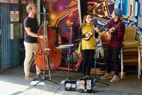
A large building was adjacent to the restaurant.  Upon hearing our accents, the two ladies inside asked if we would like to see their project.  Inside the boat house, they showed us a partially completed full-scale replica of the U.S. Schooner Independence, the first ship ever built in South Australia.  They explained that the area was first inhabited by Americans after the US Brig Union landed in 1803.  The Union's captain constructed the Independence to help with sealing operations.  The ship was presumed lost with all hands on deck on her second voyage in 1805.  For more information about their efforts to rebuild the Independence, go to http://rebuildindependence.org.

Rebuilding the Independence in American River on Kangaroo Island
We re-provisioned in Kingscote and discovered the Kangaroo Island Fresh Seafood Shop.  Fresh seafood!?!  Wow!  We purchased fresh salmon, shrimp, and whiting to eat over the next several days.  We spent the first night at a campground on Emu Bay.  The following morning, we drove to Flinders Chase National Park on the eastern tip of the island, some 110 kilometers from Kingscote.

On our way, we stopped by the Kangaroo Island Wildlife Park.  We had been told that it was a must-see.  Under misty clouds, we wondered if we should choose another day to visit.  With only two other cars in the parking lot, however, we decided that we might have the entire park to ourselves.  We almost did... not more than six other people were visiting the entire time we were there.

The small park was great fun.  We were able to photograph several animals that had been elusive in the wild.  As an example, the park had a small rookery of the endangered blue (or little) penguins.  Most had been rescued and were now in the park's breeding program.  This little lady that I photographed had been caught in an illegal fishing net and saved by the scientist on board.  The captain lost his license, and, unfortunately, the penguin lost her ability to hunt.  In her new home, she has already reared a chick.  Another female penguin was nesting while we were there.

Blue penguin, Kangaroo Island Wildlife Park
We met a wombat rescued from someone who thought raising a wombat in his house would be fun.  Because this wombat liked to be cradled, staff members would often take time during their lunch hours to hold her.  This young lady was kind enough to let me pet the wombat.  I was surprised to find its fur so coarse.

Wombat cradling at the Kangaroo Island Wildlife Park
David was followed by a pair of pelicans intent on stealing his camera strap.


We found begging wallabies in the feeding area.


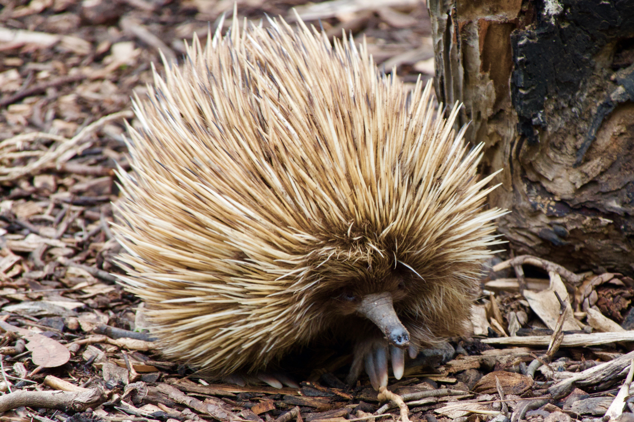
And I was finally able to take a decent photo of an echidna.  Their spines are so tough that they can actually puncture a tire if they are run over.


From the wildlife park, we drove to Kangaroo Island's national park.  Flinders Chase was one of those rare and wonderful places.  We had planned on staying only a night or two and ended up staying five.  We camped at Snake Lagoon Campground and were the only ones there for all but our last night.  Every morning and evening, a mob of about twenty kangaroos grazed in the dry lagoon.

Lounging kangaroo on Kangaroo Island
Hopping kangaroo, Kangaroo Island
Magpies visited our campsite regularly, including this recently fledged chick.  We have grown use to the magpies caroling in the morning and know it is a melody we will miss.

Newly fledged magpie on Kangaroo Island
The Flinders Chase visitor center parking lot was home to several koala.  It was fun to see so many folks walking through the parking lot, gazing up into the trees, trying to catch a glimpse of one of these iconic Australian marsupials.

Koala, Kangaroo Island
We saw one of the koalas crossing the road.  He looked a bit like a drunken sailor, wobbling back and forth as he made his way through the brush.  They are certainly much more agile climbing trees.

Grounded koala on Kangaroo Island
The grounds also had lots of Cape Barren Geese.  Some were quite testy with one another.

Cape Barren Geese, Kangaroo Island
Testy Cape Barren Geese, Kangaroo Island
We tried to find platypus on the Platypus Water Holes walk, but they remained elusive.  Over the next few days, we hiked to Remarkable Rocks.  This hike took us to granite boulders etched by wind, waves, and rain for the past 500 million years.  The photos would have been so much more dramatic under clear skies.

Remarkable Rocks, Kangaroo Island
We also visited the historic Cape Du Couedic Lighthouse, built from 2,000 pieces of local stone from 1906-1909.

Cape Du Couedic Lighthouse, Kangaroo Island
And we hiked the Snake Lagoon trail, winding through gum trees and climbing along the aptly named Rocky River.

Snake Lagoon boardwalk over Rocky River

Snake Lagoon, Kangaroo Island
Gray skies seem to follow us while we were on the island.  Our last full day, however, the sun broke through, offering a spectacular sunset and sunrise.

Sunset, Kangaroo Island
We arrived at Kangaroo Island's Seal Bay Conservation Park before it opened.  The park is home to about 400 Australian sea lions, making it the third largest colony in Australia.  Only about 45,000 of these beautiful creatures survive after they were hunted almost to extinction in the late 1800s.

David and I were the only ones in the park that early morning.  We signed up for the tour, and a young ranger guided us to the beach.  We watched a sea lion pup call for his mother.  Our guide told us the mother was probably out to sea, feeding.  She explained that sea lions have an 18-month gestation and that the pups stay with their mother another 18 months.  As a result, a female sea lion may only have three to five pups during her lifetime.  These reproduction rates have contributed to the population's slow recovery.

Sea lion pup, Kangaroo Island 
We watched a pair of adolescent sea lions spare in the waves not more than twenty feet in front of us.

Sea lions, Kangaroo Island
Later, a large bull came lumbering down the dune behind us.  Cumbersome on land, he splashed in the water and glided swiftly out to sea.


After our tour, we strolled the long boardwalk that spanned the beach.  We watched a sea eagle fly over head while sea lions surfed and played in the waves.  It looked like such fun!

Sea eagle, Kangaroo Island
Sea lion surfing, Kangaroo Island
We drove to Kingscote after our visit to the sea lion park  to make one more purchase of fresh fish for our evening meal.  We spent almost a half hour talking with the seafood shop folks.  In the grocery store, we ran into the park ranger who had been helping us.  The check-out clerk recognized us and asked how we were doing.  Everyone had made us feel so welcome.  It touched our hearts.

We spent our last night in the city park near the Penneshaw ferry landing and our early morning departure.  Honey eaters swarmed lovely flowers in the waning sunlight.


Kangaroo Island had, indeed, surpassed our expectations.  It had provided everything we enjoy... amazing wildlife, wonderful hiking, warm and friendly people, and even fresh seafood.  What more could a body ask for?

Kangaroo Island Ferry