Thursday, August 31, 2017

Staat Stats

We made it home on August 15... two days after Harvey began brewing off the coast of Africa and ten days before it hit the Texas coast (for the first time).  Stats for this trip include the following:

Days on the road:
  • 118 days on the road (four months minus four days)


Miles traveleld:
  • 15,918 miles by road
  • 1,159 miles by ferry


Number of Islands/Provinces/States visited:
  • Islands:  6 (including Vancouver, Haida Gwaii, Ketchikan, Wrangell, Petersburg, and Juneau)
  • Canadian Provinces/Territories:  6 (including British Columbia, Yukon, Northwest Territory, Alberta, Saskatchewan, and Manitoba)
  • States:  12 (including New Mexico, Arizona, Utah, Idaho, Oregon, Washington, Alaska,  Minnesota, Iowa, Missouri, Oklahoma, and Texas)

    Wow!

    Thanks to everyone for following along with us on this year's adventure.  We'll be posting more... David has a post he wants to add about taking the BC and Alaska ferry systems for those of you who might be interested in doing the same.  Of course, God willing, we plan to travel again next year.  Until then, may God richly bless each of you.

    Friday, August 11, 2017

    The Stowaway

    We broke camp at Minnesota's Woodenfrog State Campground early in the morning, ready to start our way south. We stopped by the trash bin, and while David was dumping the garbage, I noticed movement just below the truck's windshield wiper.  It was a tiny chipmunk with a very long tail.  The little critter disappeared under the hood.

    I quickly turned off the engine and popped the hood.  I told David that we had a stowaway chipmunk.  The two of us searched for the little stink, with no luck.  David assured me that he had probably hopped to the ground and scampered away when I turned off the engine.  I wasn't certain.  He had disappeared right around the windshield wiper housing.

    Within minutes of driving, it began to mist.  Then it began to rain in earnest.  I had no choice but to turn on the wipers.  I cringed at the thought of that chipmunk trapped in the windshield wiper mechanism.

    Since we had such an early start to our day, we stopped for breakfast.  Surely if the chipmunk were still in the truck, he would run for dear life.  Later we stopped for gas.  No sign of the little guy.

    That evening we stopped to camp in southern Minnesota at the Forestville State Park.  While David was inside, checking on campsites, I was shocked to see a familiar tail scurry across the windshield.  Then he disappeared once again into the windshield wiper housing.

    David was as surprised as I had been when I told him the news about our stowaway.  We drove through the campground to find a site, then returned to the park office to register.  I turned the engine off and waited for David... and the chipmunk.  Sure enough, the little critter came out of the housing again.  This time, however, he launched himself off the hood of the truck and onto the road.  He dashed about 15 feet, then turned around and took a good, long look at the truck.  Within a few seconds, he disappeared into the forest.

    Now I was worried if he could survive in his new home.  Thankfully, I saw several other chipmunks in the area later that evening.  They weren't as tiny as ours, but at least I knew that he had a chance.

    I can't imagine how that chipmunk survived his ordeal.  He had been transported over 400 miles above a noisy, hot engine.  Who knows what he went through when I had the windshield wipers going.  Without a burrow, he would now be exposed to additional predator dangers.

    I sure hope the little guy makes it.  One thing is for certain... that chipmunk will never stow away in a vehicle again!

    Thursday, August 10, 2017

    Voyageurs National Park


    Voyageurs National Park
    We crossed into the Lower 48 on Sunday at Warroad, Minnesota.  It felt great to be back in the old U.S. of A.  We had four days to play before our scheduled visit to David's mom, sister, and her husband.  What to do?

    While studying the Minnesota map, we had found an intriguing green area... Voyageurs National Park.  We had never heard of it.  Our road atlas indicated that it is one of the least visited of our national parks.  The park is situated on the northern border of Minnesota and Canada on Lake Kabetogama, just west of the Boundary Water Canoe Area Wilderness.  David had once dreamed of being a park ranger, canoeing the boundary waters between the States and Canada.  It looked like the perfect spot for us to end this year's camping adventure.

    By the time we arrived at the Rainy Lake visitor's center, it was closed.  We quickly discovered that there were no campgrounds within the park accessible by car.  In fact, the only way to get into the park is to travel by boat or plane.  The nearest campground to us outside the park was Woodenfrog State Campground near Kabetogama. We drove there and found a lovely state park, heavily wooded and with lots of room between sites.  It was the perfect launching place to discover more about the area.

    Voyageurs National Park is named after the French-Canadian canoemen who ferried trade goods across these waters during the late 1700s and early 1800s.  The surrounding landscape includes boreal forests that meet and mix with northern hardwood forests.  It is home to a wide variety of wildlife, including bear, eagle, beaver, otter, moose, and the elusive timber wolf.

    We visited the Ash River Visitors Center the following morning to learn more about the park.  The ranger suggested we either rent a boat or take a water taxi to Kabetogama Peninsula.  Unfortunately, the park's water shuttle service was booked until Thursday.  The park's shuttle drops visitors off at the only motel lodging within the park... the historic Kettle Falls Hotel.  The shuttle also offers visitors access to the peninsula's 52 miles of hiking trails.

    We spent the rest of the day visiting a few boat rental places, finding the best deal at the Arrowhead Lodge.  Then we took a much-needed hike on the Echo Bay trail loop.

    The following morning, we arrived at Arrowhead Lodge and rented our aluminum fishing boat.  The kind owners suggested that we head toward Cutover Island, circle around, and visit the Ellsworth Rock Garden.


    As we left the marina, we saw two children diving from one of the floating docks.


    On one of the little rock islands, we spied pelicans, gulls, and several cormorants drying their wings.

    Birds gather on a rock island, Voyageurs National Park

    We docked at the historic sculpture gardens about an hour later.  Jack Ellsworth built these gardens between 1944 and 1966.  He took a 60-foot-tall granite outcropping, created dozens of rock and wooden sculptures, and accented the area with flowers.  After his death, the gardens fell into disrepair.  Deer now graze on the remaining lilies, however, the park has acquired the grounds and has begun restoring the gardens.

    Ellsworth Rock Gardens, Voyageurs National Park
    Arrowhead sculpture, Ellsworth Rock Garden
    Teepee sculpture, Ellsworth Rock Garden
    We had the option of renting the boat for a half or full day.  After about three hours, the skies made the choice for us.  Heavy clouds began to gather and the wind began to rise.  We made it back to the marina just minutes before it began to rain.

    What a great place!  Voyageurs is definitely a park we want to visit again.  We can just imagine having a water taxi take us and kayaks out to one of the island campsites so that we can paddle around, looking for animals or fishing.  Or perhaps we can entice friends and family to join us and rent a houseboat for several days.  Or maybe we will even stay at the Kettle Falls Hotel and hike the trails along the peninsula.  

    Voyageurs is just our kind of place... cool temperatures during the day (even in August!), few visitors, and lots of water. 

    Lilies, Ellsworth Rock Garden


    Monday, August 7, 2017

    August Long

    Sunset over Lesser Slave Lake
    August Long is a civic holiday in Canada, celebrated the first weekend and following Monday in August.  It is the busiest travel holiday in Canada.  Most services are closed, including all government offices, as well as many local businesses.  Additionally, because Canadians love the outdoors and most enjoy camping, campgrounds are booked months in advance for this weekend.  We didn't know August Long existed.  We do now.

    We had our first inkling that something was amuck while traveling across Alberta.  We stopped to camp at Lesser Slave Lake.  The area was beautiful but incredibly crowded (and buggy).  To top it all off, David ended up with a touch of food poisoning.  Needless to say, while the scenery was lovely, we did not enjoy our stay.

    Sandpipers on the shore of Lesser Slave Lake
    We packed up the next morning and headed to Prince Albert National Park.  We were told that we would only be able to stay one night because the entire park was booked through the holiday weekend.  What holiday, we asked?  It was then that ranger informed us about August Long.

    David and I have been caught in Canadian holiday weekends in the past.  We have learned to find a campsite, hunker down, and ride it out.  This time, however, we didn't have a campsite.  So we drove.  We spent two hours looking for a campground in Meadow Lake Provincial Park.  By the time we arrived at the site, we were too tired to do anything more than stroll around our little camping circle.

    The following day, a lady at the visitor center in La Ronge told us that Missinipe (pronounced Miss-nippy) would certainly have sites available.  We found the Churchill River campground at the end of the road near Otter Rapids, but soon we had to move to another place when a kind camper explained their reservation system.   It felt like we were camping to musical chairs, and we were the last rig standing.

    Otter Rapids on the Churchill River, Saskatchewan
    Not knowing where to camp next, we decided that our best bet was to make the States as soon as possible.  We left Saskatchewan at 4:30 Saturday morning and crossed Manitoba diagonally.  We passed so many lakes and beautiful countryside, but we didn't dare stop.  By the time we arrived at the Watchhorn Bay campground, it was 5:30 in the evening.  We had driven over 600 miles.  We were relieved when we drove through the campground.  One site was empty.  Unfortunately, the camp host had stepped away from her desk.  We waited.

    When she returned, we told her our plight.  We were exhausted and desperate.  The campground, however, had no overflow sites.  She told us the empty site was one that had been reserved for the season.  Although the family who had reserved it had pulled their camper because it needed repairs, the camp host would not allow us to stay in it.  We asked if we could simply pop the top on our rig for sleep and not utilize any of the campground's amenities.  She said no.  She also told us that Manitoba did not allow boondocking.  All campers must be in designated campgrounds.  She apologized and sent us on to Ashern and their city campground, which showed openings on her computer.  When we arrived at the Ashern campground, however, we found that it was completely reserved for a wedding... as was the town's only motel.  Again, we drove on.

    Finally, we saw a sign for the Twin Lakes Provincial Park.  It was thirty minutes off the main road, but we decided to take the chance since the GPS indicated that only other town we would encounter with motels was Winnipeg, over two hours away.  When we arrived at Twin Lakes, we found a note on the camp host's door that she would return at 8:45.  We waited the additional twenty minutes.  Thankfully, this camp host always left one site open for travelers like us.  David paid for the site.  When we went to set up camp, however, another rig was already there.  The camp host quickly explained to the young people that we had rented the site and sent them on their way.

    I can't explain our gratitude and relief.  We had driven nearly 700 miles in one day.  Needless to say, we were exhausted.  Only three hours separated us and the U.S. border.  After our experience with August Long, those beautiful Stars and Stripes will be a welcomed sight, indeed!

    Tuesday, August 1, 2017

    The Alaska Highway... an old friend

    Mucho Lake
    I remember well our first trip up the Alaska Highway in 2010.  It was such an adventure.  Every turn was a complete unknown.  Now it feels like an old friend.  We have our favorite stopping spots.  We treat ourselves to spaetzel and schnitzel at the Wolf's Den in Whitehorse.  We know that the best wildlife concentration is between Liard Springs and Toad River.  Contact Creek always has the cheapest gasoline.  We love strolling along Muncho Lake.  And to keep from experiencing a complete sugar overload, we enjoy splitting just one of the enormous sticky buns at the Tetsa River Lodge.

    After leaving the Dempster, we felt more than a bit melancholy.  We were heading home at the time of year we normally are heading north.  We had already missed the salmon runs in Valdez and Haines because we were too early. Now we would miss the fall colors.   We would also miss the bird migrations and first snowfall.  In many ways it also felt like we were being pushed home.

    Around Liard Springs, we finally saw some wildlife.  We stopped to photograph a herd of wood bison.  Nearby, we also saw a sow with twin cubs, but she disappeared into the forest before I could roll the window down.  Further south, we saw stone sheep grazing.


    Stone sheep grazing
    We planned to spend several days enjoying Muncho Lake.  I was missing Roxanne so much... this was one of her favorite spots.  We took a stroll, and I could almost see her bounding before us on the trail, looking back to see if I would give the signal so she could dive in the lake.  Tears were stinging my eyes when we heard distant thunder.

    We decided we better turn around.  We barely made it back to the camper before the skies opened up, and it began to rain.  It rained all night.  And during the night, we saw something we had not seen in a very long time... darkness.

    We stopped by the Northern Rockies Lodge the next morning and learned the forecast predicted rain to continue through the next several days.  So we drove on...  The rain followed us nearly to Fort Nelson.  Here the terrain changes quickly from mountains to pasture land.  By the time we arrived in Dawson Creek, we were surrounded by fields and fields of canola and their stunning yellow flowers.

    Canola fields near Dawson Creek
    The next day, the rolling hills gave way to prairie.  It felt comforting somehow to be back in farming country. Both David and I come from rural backgrounds, and we reminisced about childhood days.  The scenery looked like a beautiful quilt pattern with patches of yellow canola flowers, rows of olive-green wheat, and all dotted with enormous rolls of caramel-colored hay.

    With reports of dozens of forest fires and road closures in British Columbia, we turned east.  We would take a different route home this trip, traveling through Saskatchewan and Manitoba before entering the Lower 48 somewhere in Minnesota.  From there, we would spend a few days with David's mom in Missouri before heading home.  We looked forward to this new route... we had only skirted Saskatchewan once a few years ago, and we had never been to Manitoba.  A new adventure certainly was waiting for us.


    Sunday, July 30, 2017

    An Unfamiliar Dempster Highway

    Tombstone Valley, the Dempster Highway
    It's probably no surprise to our regular readers... the Dempster is my favorite road on the planet.  It is always the highlight of our trips to this part of the world.  I love it for its animals, its rugged remoteness, and for its surprises.

    After hearing rumors of fires and road closures for weeks, we stopped at the Visitor's Center in Dawson City to check on road conditions.  The Dempster was open.  When we asked about the fires, the young lady said there may still be some smoke around KM marker 280, but that the fire was mostly out.  She encouraged us to travel the road, saying the road was open all the way to Inuvik.

    We didn't think to ask how big the fire was.  We later learned that the aggressive blaze had begun with a lightening strike.  It scorched over 325,000 acres.  We traveled over twenty-five miles of road charred on either side from the enormous fire.  We saw several still-smoldering plumes wafting from the remains of ghostly, blackened trees.  Road crews were vigilant, traversing up and down hot spots.  At the viewing platform on Olgivie Ridge, all we could see was the charred remains of boreal forests and high tundra grasses.  This fire had been devastating.

    Dempster boreal forest fire 2017
    2017 Dempster fire from Olgivie Ridge
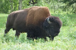
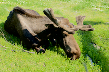
    We had never been up the Dempster in the middle of summer.  Normally we travel as autumn begins in late August or early September.  This trip was so much different.  We have always seen all kinds of animals.  But between the fire and the time of year, this trip's sightings were scarce.  When we did see animals, they were skittish and visible for only seconds.  Near the fire remains we saw a moose cow and calf, a young black bear, and a black wolf crossing the road.  At the sound of our truck, they disappeared quickly.  I was only able to photograph the little black bear.

    Black bear grazing on Dempster Highway
    After boondocking at a favorite spot near Eagle River, we stopped at Eagle Plains the following morning for breakfast.  We spoke with the manager who was also devastated by the fire.  She told us that she feared mostly for the caribou.  The fire had scorched so much earth that she wondered if the tundra grasses could now support the herd this winter.  We told her that normally we see mother bears grazing with their cubs near Eagle Plains.  She told us arial photos showed that the fire had driven them all north.  We all feared that many animals had lost their lives.

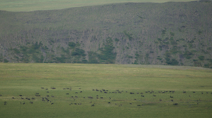
    As we neared the Yukon/Northwest Territory border, we were shocked to see a large herd of caribou grazing in the distant meadow.  It was the wrong time of year to see these magnificent animals, particularly in such great numbers.  Normally this area is their winter feeding grounds.  Perhaps the fire had driven them down from the high country.

    We were also shocked to see hunters... dozens of them.  We couldn't believe hunting would be allowed in July.  Through binoculars, we could see several hunters field dressing their kill.

    Caribou on the Dempster in July
    With all the hunting activity, we drove on and stopped in Fort McPherson to check on our friend Robert who runs the provincial campground and visitors center.  Another man met us, explaining that Robert had been ill but was doing better after treatment.  I told him that Robert had always asked us for a caribou report and that we had seen several hundred at the border.  We also told him that we had seen hunters.

    He shook his head.  His voice contained sadness.  He said it was a rare gift to have caribou in the valley in the summer.  The people should not be hunting... they didn't need the meat now.  They should let the caribou settle in and become comfortable.  He told us that the tribe had sent elders to speak with the hunters and try to dissuade them.

    In this part of Canada, the local Gwich'in tribes regulate the hunting season.  This man was obviously one of the elders and was distraught over the turn of events.

    It was still early in the afternoon.  Hoping to see more animals, we made the decision to drive all the way to Inuvik. Perhaps we would see black bear in the Delta.  There were none.

    We arrived at Jak Provincial Park around six that evening and set up camp in misty rain.  By the time we had showers, the clouds parted, and the sun reappeared.

    The town of Inuvik sits above the Arctic Circle, and we were obviously still in the land of the midnight sun.  I took this photo from inside the camper at 2:30 in the morning.  The sun didn't quite set.  It simply skirted the horizon for a bit before rising again.

    A Dempster sunset... 2:30 am in July
    The next morning, we drove into the town of Inuvik and discovered that our favorite cafe had closed.  The lady at the visitors center told us that the cafe's owner had passed away suddenly.  She also told us that the anticipated new road extension to Tuk had been delayed until November.  It definitely felt like we had hit the end of the road.

    We decided to turn around and drive back south.  When we arrived again at the border, we saw several trucks and men but no hunters.  Perhaps these were the elders sent to discourage hunters.  It was hard to believe that we had been here just 24 hours earlier and the place had been buzzing with activity.  Now it appeared desolate.  The caribou herd had vanished.  Using his binoculars, David scoured the horizon for signs of life.  Off in the very far distance, he spied a grizzly bear, probably grazing a gut pile from a caribou kill.  We camped at Rock Springs, with plans to drive back to the border next morning.  Surely we would see animals.  We didn't.  Even the elders were gone.

    We felt disheartened.  Everything seemed different on the Dempster this trip.  We made the decision to leave the next morning.

    On the Dempster Highway, between Tombstone and Two Moose Lake


    Our last night on the Dempster, we camped in a favorite spot near a field of fireweed.  Fireweed is so named because in a temperate forest, it is the first plant to colonize after a fire.  

    Surely, these flowers were a good omen.  We will plan another trip up the Dempster, perhaps even returning next fall.  Our prayer is that the fireweed will grow, and the Dempster and its animals will continue to thrive.  

    Fireweed on the Dempster Highway


    Saturday, July 29, 2017

    An update from Hurricane Central

    Update September 17, 2017:

    Dear Friends, Please forgive me for not posting the remainder of our trip sooner.  We had such difficulty finding internet access during this trip that I planned to finish posting when we arrived home.  Little did we know that Hurricane Harvey was brewing in the Gulf of Mexico.

    Less than a week after we came home, Harvey hit the coast of Texas.  Near the eye of the storm, my mother and sister received minor damage in comparison to most.  Family south of Houston received 44 inches of rain and a leaky ceiling.  Another's car was flooded.  David and I received 38 inches of rain at our house but remained high and dry.  Unfortunately, many of those surrounding us were not as fortunate.  As a result, we have spent many of our days since Harvey helping to muck out flooded homes and distribute needed items.

    It will take months, if not years, for the coast of Texas to recover from this deadly storm.  However, spirits remain high.  It has been amazing to see the generosity of neighbor helping neighbor and the commitment from all of us to lift up those who need it most.  By God's amazing grace, we remain Texas strong.  God bless you all.

    Now, let the post continue!

    Monday, July 24, 2017

    Eagle, Alaska

    Eagle, Alaska, overlooking the Yukon River
    One of our very favorite places in Alaska is the small town of Eagle.  It sits on a Yukon River bend, surrounded by mountains and the enormous Yukon Charlie National Preserve (accessible only by boat or plane).  This is rugged, beautiful country.  About 80 residents make Eagle home throughout the year.

    Eagle is the kind of town very few people visit as a tourist destination.  The town rests at the end of the Taylor Highway, up 72 miles of gravel road, north of Chicken, Alaska.  Once the snow flies, the road shuts down and is not maintained.  The only way in and out of Eagle is via airplane, snowmobile, or dog sled.  Eagle has no tourist attractions other than its beautiful scenery and the remains of Fort Egbert.  It also has very few amenities besides a well-kept BLM campground, one motel, and a bed and breakfast.  There is no cell service, and internet is only available when the library is open.

    It is the people that continue to draw us back to Eagle.  They are an independent lot, yet there is a tangible commitment to their neighbors and the community.  This is our third trip to Eagle.  Over the years, we have made several friends here.  Never, however, have we come this early in the season.  We found the community very busy, indeed.

    There is a saying in Alaska that it is either winter or you are preparing for it.  We discovered all of our friends preparing.  One of the first questions we heard was, "Did you see caribou?"

    We had seen caribou near the Taylor junction.  These caribou are but a small portion of the nearly 50,000 members of the Fortymile caribou herd, named after the Fortymile River, a tributary of the Yukon River.  Eagle is a subsistence hunter community, one that relies on the land to provide food.  A single caribou can sustain a family throughout the long winter.  With hunting season only a few weeks away, everyone was interested in the caribou's location.

    Members of the Fortymile caribou herd
    King salmon had also begun their run up the mighty Yukon.  One of our friends took us on their boat across the Yukon River to see the fish wheel they share with another family.  The fish wheel is believed to be a Chinese invention and was brought to North America in the 1800s.  The contraption revolves in the river's current, scooping salmon swimming upriver, and depositing them in baskets for easy retrieval.  I took this video of the fish wheel in operation...


    The families had just harvested 36 fish.  The salmon were filleted, skinned, sliced into long slivers, and soaked in a brine solution.  Each strip of fish was then hung on a rack and smoked for over a week.  David and I were rookies but glad to help place a few of the fish silvers on the racks.  Here's a photo that David took of the inside of the smokehouse.

    Salmon smokehouse
    We also were privileged to visit the Eagle Bible Chapel for their Sunday worship service again.  This church is unlike any we have ever attended.  The congregation focuses on the Bible, music, and outreach.  The small congregation is made up of many extremely talented musicians, including a keyboardist, flutist, violinist, two guitarists, and a trumpeter.  It is always a delight to worship with these folks.

    We left Monday morning.  Our plans were to stop at the Visitor's Center in Dawson City to determine if going up the Dempster Highway was practical.  Rumors about fires shutting down the road continued to swirl.

    Friday, July 21, 2017

    Back to the Nebesna Road... one more time

    View from the Nebesna Road
    After Morgan left, we spent the night in the motel, keeping track of her flight's progress.  About 3:30 am our time, her mom texted that Morgan had landed and was safe with her in Atlanta.  With a huge sigh of relief, we were able to turn over and sleep soundly the remainder of the night.

    The next morning, it took us longer to complete our list of Anchorage errands than we had planned, so we camped one last night at Eagle River.  The back seat certainly felt empty again.

    Now we had to decide… what to do next?  Without Morgan, it felt like the whole tenor of the trip had changed.  We had been on the road just over three months but weren’t quite ready to go home.  We still had some unfinished business.  We knew we wanted to be in Eagle on Sunday to meet with friends, and, of course, we wanted to drive the Dempster up to Inuvik again. 

    We decided to go back to the Nebesna Road for a few more days.  Between David's pulled calf muscle, Morgan's boot, and rainy weather, even with two prior visits to the Nebesna this trip, we still hadn't been able to take the hike up to the Rambler Mine.  With David's leg now healed, we had the time and the opportunity.  We also wanted to make reservations to stay at the Viking Lodge, a walk-in cabin on the Nebesna.  So off we went, back to the Nebesna Road, hoping for good weather this trip.


    Although the Wrangell range was draped in clouds during our entire stay, we had beautiful weather in the valley during this trip up the Nebesna.  We hiked the Rambler Mine trail.  It is a relatively short hike, just under a mile one way, however, it gains over 400 feet in altitude in a mere half mile.  Pretty steep for us flatlanders!

    The Rambler mine was once an operative gold mine during the 1940s.  The mine shaft is now barred from exploration, however, much of the old equipment and buildings were abandoned and are still visible.

    Rambler gold mine with ore tram behind bars

    Rambler mine
    And, of course, the views from the Rambler Mine were incredible...


    The following day we trekked the short quarte-mile hike to the Viking Lodge.  This cabin is reservable without charge with the National Parks Service.  The cabin was built in the late 1960s/early 1970s by a homesteader.

    Much of the hike to the cabin is over boggy marsh, so it was no surprise to us that it would be buggy.  We were not, however, prepared for just how buggy it would be.  We spent several hours at the cabin, enjoying the area.  Ultimately, however, we decided to hike out rather than spend the night.  While the cabin was quite comfortable, we had envisioned sitting outside and enjoying the evening.  The mosquitos and gnats made that impossible.  We figured we could go back to our old campsite, set up our screened tent, and enjoy the evening there much better than being cooped up in the cabin until morning.

    Viking Lodge on Nebesna Road
    Inside Viking Lodge on Nebesna Road
    We left the Nebesna Road the following morning.  Our next destination was Eagle, Alaska.  We were delighted to once again have the opportunity to meet with friends there.  From Eagle, we would attempt the Dempster.  We had heard rumors from folks over the past several weeks that the road was closed due to fires.  How could we end our trip without going up the Dempster?  Only time would tell...

    Saturday, July 15, 2017

    We're sure going to miss that girl!

    Goodbye, Sweet Morgan!
    We only had three days remaining with Morgan.  It was hard to believe that the time had gone by so quickly!  

    For our final time together, we had thought about walking the Matanuska glacier, but the hike was over a half mile one direction, in and over rugged, muddy terrain.  With Morgan's ankle still a bit sore and swollen from walking the Kennicott mine, we felt it would be too much for her.  When we awoke to more rain, we easily made the call to abandon the idea.

    We camped again at Eagle River, where we had camped the first night Morgan had arrived.  The following morning we drove down the Turn Again Arm, south of Anchorage, hoping to see belugas.  Our ultimate goal was to visit the Alaska Wildlife Conservation Center near Portage.

    David and I had visited the park in 2010 and, quite honestly, had felt sorry for the animals.  Several folks had told us they had made major renovations over the past few years and that we should try them again.  They were right.  The animals were in much better environments, and the park had made many more improvements.

    Morgan was able to see porcupines, moose, muskox, bison, and bear up close and personal.  

    Porcupine at Wildlife Conservation Center
    Moose at Wildlife Conservation Center
    Muskox at Wildlife Conservation Center
    Muskox and baby at Wildlife Conservation Center
    One gigantic brown bear strolled close by us, finally settling on a log to take a snooze.  I was so glad Morgan could finally see how amazing these magnificent creatures truly are.

    Brown Bear at Wildlife Conservation Center 
    Brown Bear takes a snooze at Wildlife Conservation Center 
    After our visit to the wildlife center, we camped at another favorite place... Black Bear campground.  David set up the hammock, and he and Morgan took turns being lazy.  It was a great afternoon.


    The next day we took a short hike and took in the visitor center's interpretative museum... we even met an old friend, Smokey the Bear.  Afterwards we tried to catch up on blog posts and started organizing Morgan’s things back into duffle bags.

    Morgan and Smokey the Bear
    It was a glorious last few days with Morgan.  We were delighted with our sunny skies.  Temperatures were even predicted to reach 71 degrees on Friday.  When weathermen posted an extreme heat alert because of soaring temperatures, we had to chuckle… friends were reporting 94 degrees at home in Texas.  When we have 71 degrees at home, we’re still wearing long sleeves and have the windows open!  What a difference!  Of course, we knew the opposite was true... Alaskans would simply shake their heads at us when a half inch of snow shuts down nearly the entire state of Texas.

    One more night of camping at Black Bear, and our adventure with Morgan was over.  We drove into Anchorage Friday morning and took Morgan to lunch at Sook’s wonderful restaurant, Alaska’s Gourmet Subs.  Afterwards, we checked into a motel near the airport so that Morgan could take a shower, and we could finish packing all her gear. 


    Her flight was right on time, leaving at 8:10 in the evening.  Hugs around and then goodbye.  Wow!  We sure are going to miss that girl!