 |
| Tombstone Valley, Dempster Highway |
We began travelling the Dempster with high hopes, anticipation, and a bit of trepidation. Weather reports were not good. They predicted rain during much of our trip. We were delighted, however, when the clouds parted just as we reached the Tombstone visitor centre.
After checking with the rangers to verify good road conditions, we immediately drove to the Tombstone Valley overlook. Tinges of gold were everywhere. In this part of the world, we have learned that autumn comes and goes quickly, sometimes in as little as seven to ten days. Perhaps autumn gold will shine on us this trip.
We traveled through the first section of the Dempster, stopping at Two Moose Lake, which, unfortunately, had only ducks swimming around. Sam, our bird dog, however, was very interested.

We camped in a familiar, off-the-road spot near a shallow lake. We had barely set up camp when it began to rain. Around midnight, Sam wakened us with sharp barks, indicating an obvious intruder. David heard splashes. We figure a wayward moose had ventured into the lake, and that Sam had alerted to it, causing it to flee.


 |
| View from Olgavie Ridge, Dempster Highway |
It was on to Eagle Plains (population 8), a government outpost with a motel, restaurant, gasoline, and a small service and maintenance building. A large boreal forest burn area had nearly evacuated the area just weeks before. The fire was so fresh, we could still smell the smoke.
 |
| Boreal forest burn area near Eagle Plains, Dempster Highway |
By the time we reached the Arctic Circle, the temperature had dropped into the 40s, and the wind was fierce. We doned practically every layer of clothing we could. The wind blew so hard that we had difficulty keeping the camera on the tripod to take this timed photo. We had to use the truck as a wind shield.
 |
| Us at the Arctic Circle... Sam is most interested in the ground squirrels. |
 |
| Arctic Circle panoramic, Dempster Highway |
The weather offered some interesting clouds, including this alien-looking one.

A few miles away, we spied our first brown bear at a distance before the rain began in earnest.
 |
| First brown bear we saw on the Dempster Highway |
By the time we reached Rock River, we were driving in and out of rain. The Black Valley (so named because of the black shale in the area), was already christening the truck.

As we neared the Yukon/Northwest Territory border, the sun played with the clouds, and we chased rainbows. The border itself, however, was socked in with fog, so we retreated to our campsite at Rock River, hoping for better weather in the morning.
 |
| Chasing rainbows near the Yukon/Northwest Territory border. |
It rained steadily most of the night, and the border was still engulfed in fog in the morning. We traveled on, hoping for a break in the clouds. Unfortunately, we found none until we reached the Mackenzie Delta.
We did spy a fox hunting along the road. Sam went nuts when she saw him, so we had to put her in her riding safety harness to keep her under control (and inside the truck!).
 |
| Red fox hunting the road, Dempster Highway |
The Dempster has two ferry crossings, both free of charge. The ferries are pulled when the rivers freeze. Travelers must wait until the rivers are frozen enough to turn into ice roads. The first is a cable ferry across the Peel River.
 |
| Peel River ferry, Dempster Highway |
The second is a free-floating, motorized ferry across the Mackenzie River. This ferry has three landings, including one to the community of Tsiigehtchic, a small indigenous hamlet with a population of 138. In the photo below, you can see the Tsiigehtchic church on the far right.
 |
| Mackenzie River and ferry (far left) with Tsiigehtchic church on far right . |
It was fairly sunny as we drove the Mackenzie Delta road, which made the dust conditions dangerous. Whenever we crossed paths with other vehicles, particularly big rigs, we were engulfed in dust so thick that visibility was zero. Each time we saw another vehicle approaching, we pulled over and waited a minute or two for the dust to settle before travelling on. Thankfully the road isn’t heavily traveled.
 |
| Mackenzie Delta, Dempster Highway |
We drove on to Inuvik, the largest town along the Dempster, with a population of just over 3,000 people. We stopped at the visitor centre to again check road conditions. I finally took a good photo of a musk ox to show you… albeit stuffed.
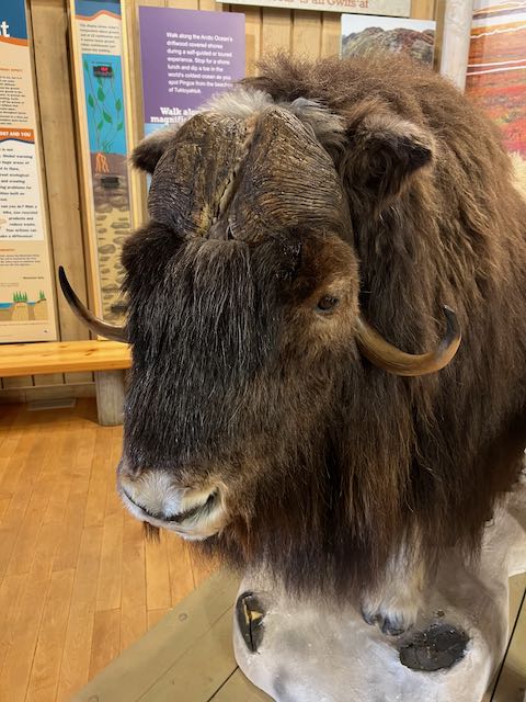 |
| Stuffed musk ox at Inuvik Visitor Center |
The Igloo Church is the most iconic photo to take in Inuvik. Formerly named the Our Lady of Victory, the church was originally built in 1960 and rebuilt in 2005. The building is meant to imitate the Inuvialuit snow houses of old.
 |
| Igloo Church, Inuvik, Dempster Highway |
We stayed at a favourite spot, Jak Territorial Campground. It has great showers and is close to town. Tomorrow morning, we plan to travel to Tuktoyaktuk (population 900), the northern most town on the Dempster and the Arctic Ocean. Our Texas pup, Sam, will have traveled for the first time from the Gulf of Mexico to the Arctic Ocean. How special is that?
No comments:
Post a Comment