Thursday, August 24, 2023

Dempster 2003, Part One

Tombstone Valley, Dempster Highway

We began travelling the Dempster with high hopes, anticipation, and a bit of trepidation. Weather reports were not good. They predicted rain during much of our trip. We were delighted, however, when the clouds parted just as we reached the Tombstone visitor centre. 

After checking with the rangers to verify good road conditions, we immediately drove to the Tombstone Valley overlook. Tinges of gold were everywhere. In this part of the world, we have learned that autumn comes and goes quickly, sometimes in as little as seven to ten days. Perhaps autumn gold will shine on us this trip. 


We traveled through the first section of the Dempster, stopping at Two Moose Lake, which, unfortunately, had only ducks swimming around. Sam, our bird dog, however, was very interested. 


We camped in a familiar, off-the-road spot near a shallow lake. We had barely set up camp when it began to rain. Around midnight, Sam wakened us with sharp barks, indicating an obvious intruder. David heard splashes. We figure a wayward moose had ventured into the lake, and that Sam had alerted to it, causing it to flee. 


The next morning, we drove to Olgavie Ridge. Three ravens greeted us in the cold and blustery wind. The clouds continued to gather. 


View from Olgavie Ridge, Dempster Highway

It was on to Eagle Plains (population 8), a government outpost with a motel, restaurant, gasoline, and a small service and maintenance building.  A large boreal forest burn area had nearly evacuated the area just weeks before.  The fire was so fresh, we could still smell the smoke.


Boreal forest burn area near Eagle Plains, Dempster Highway

By the time we reached the Arctic Circle, the temperature had dropped into the 40s, and the wind was fierce. We doned practically every layer of clothing we could.  The wind blew so hard that we had difficulty keeping the camera on the tripod to take this timed photo. We had to use the truck as a wind shield.


Us at the Arctic Circle... Sam is most interested in the ground squirrels. 

Arctic Circle panoramic, Dempster Highway

The weather offered some interesting clouds, including this alien-looking one. 


A few miles away, we spied our first brown bear at a distance before the rain began in earnest. 


First brown bear we saw on the Dempster Highway


By the time we reached Rock River, we were  driving in and out of rain. The Black Valley (so named because of the black shale in the area), was already christening the truck. 


As we neared the Yukon/Northwest Territory border, the sun played with the clouds, and we chased rainbows. The border itself, however, was socked in with fog, so we retreated to our campsite at Rock River, hoping for better weather in the morning. 


Chasing rainbows near the Yukon/Northwest Territory border.

It rained steadily most of the night, and the border was still engulfed in fog in the morning. We traveled on, hoping for a break in the clouds. Unfortunately, we found none until we reached the Mackenzie Delta.


We did spy a fox hunting along the road. Sam went nuts when she saw him, so we had to put her in her riding safety harness to keep her under control (and inside the truck!). 


Red fox hunting the road, Dempster Highway

The Dempster has two ferry crossings, both free of charge. The ferries are pulled when the rivers freeze.  Travelers must wait until the rivers are frozen enough to turn into ice roads.  The first is a cable ferry across the Peel River. 

Peel River ferry, Dempster Highway


The second is a free-floating, motorized ferry across the Mackenzie River. This ferry has three landings, including one to the community of Tsiigehtchic, a small indigenous hamlet with a population of 138.  In the photo below, you can see the Tsiigehtchic church on the far right. 


Mackenzie River and ferry (far left) with Tsiigehtchic church on far right .


It was fairly sunny as we drove the Mackenzie Delta road, which made the dust conditions dangerous. Whenever we crossed paths with other vehicles, particularly big rigs, we were engulfed in dust so thick that visibility was zero. Each time we saw another vehicle approaching, we pulled over and waited a minute or two for the dust to settle before travelling on. Thankfully the road isn’t heavily traveled. 


Mackenzie Delta, Dempster Highway

We drove on to Inuvik, the largest town along the Dempster, with a population of just over 3,000 people. We stopped at the visitor centre to again check road conditions. I finally took a good photo of a musk ox to show you… albeit stuffed. 
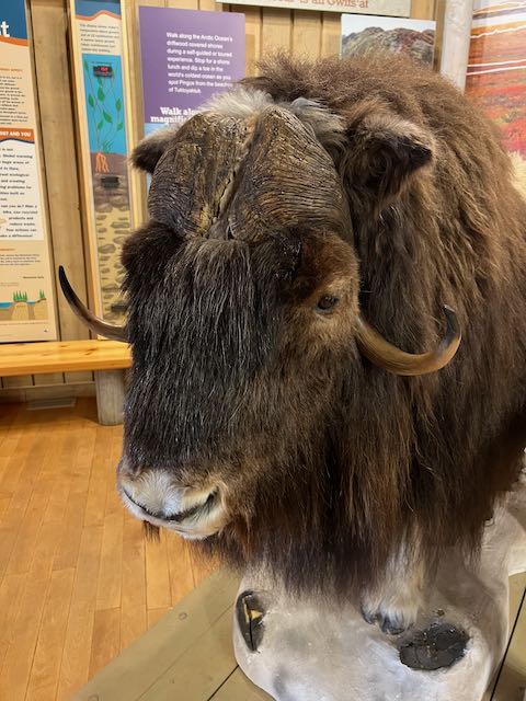

Stuffed musk ox at Inuvik Visitor Center


The Igloo Church is the most iconic photo to take in Inuvik. Formerly named the Our Lady of Victory, the church was originally built in 1960 and rebuilt in 2005.  The building is meant to imitate the Inuvialuit snow houses of old. 


Igloo Church, Inuvik, Dempster Highway

We stayed at a favourite spot, Jak Territorial Campground. It has great showers and is close to town. Tomorrow morning, we plan to travel to Tuktoyaktuk (population 900), the northern most town on the Dempster and the Arctic Ocean. Our Texas pup, Sam, will have traveled for the first time from the Gulf of Mexico to the Arctic Ocean. How special is that?  


Tuesday, August 22, 2023

Savoring the Dempster... yet again

Tombstone Valley on the Dempster Highway, Yukon

I’ve often said that the Dempster is my favorite road. It is 543 miles of winding gravel road connecting communities and people from the gold rush days of Dawson City to the small, indigenous community of Tuktoyaktuk and the Arctic Ocean. This is our seventh trip on the Dempster. 

But the Dempster is more than just a road. It is a place where the Porcupine caribou herd winters. Brown and black bears flourish. Moose outnumber people. Wolves and fox abound. And millions of birds migrate here to nest and raise their young before migrating back south for the winter. 


Dempster brown bear from a past trip.


The Dempster has a vastness that is indescribable. It has a beauty that only God could create. The first section of the Dempster traverses the Klondike Plateau, the Mackenzie Mountains, and onto the Olgavie Mountains. Riding the rim of Olgavie Ridge is an amazing run. It takes you high above the boreal forests to alpine tundra cloaked in rich green moss, lichen, sedges, and grasses.  Ultimately the road leads you to Eagle Plains, a lodge and government outpost for weary travelers. 


Olgavie Mountains, Dempster Highway, Yukon


At the Arctic Circle, the Richardson Mountains (the most northerly extension of the Rocky Mountains) come into view. The Dempster crosses these mountains at Wright Pass, which is also at the Yukon/Northwest Territory border where caribou migrate to and overwinter. If indigenous hunters are tracking, you can be sure to find brown bears. The bears have become accustomed to following gun shots, knowing that soon a welcomed gut pile is theirs for the taking. 


Beyond the border between the Yukon and Northwest Territories, and after taking ferry crossings on the Peel and Mackenzie rivers, lies the Mackenzie River Delta. It is the tenth largest delta in the world and ranks seventh in the world in terms of flow, exceeded in the western hemisphere only by the Mississippi and the Amazon. 


The Dempster is home to the Gwinch’in and Inuvialuit First Nation peoples. The Inuvialuit live in Arctic Canada, mostly above the town of Inuvik. The Gwinch’in live in the basins of the Yukon and Peel Rivers, mainly below Inuvik. Both peoples strive to live off the land in a climate that is cold, mostly dark, and often unforgiving. 


For travelers, the Dempster can be treacherous. It must be respected at all times. Speed and fatigue are its worst enemies, particularly when folks try to traverse the 543 miles in a single day or two. Traveling above 50 mph can be deadly because conditions change on a dime.  There are washboards, frost heaves,  potholes, and sharp, exposed rocks at every corner. A fellow who refused to take the road with an RV group told us that they later reported three flat tires and a broken drive shaft. A native of Inuvik explained it best, “You can go as fast as the number of tires you want to change.”  


Below is a photo of a wreckage we saw this morning along the roadside… most likely due to speed, poor soul. We have not been able to find out if he survived the crash. 


Poor weather conditions are an additional hazard. The weather changes quickly here. Damp, gale force winds prevail. Rain turns to sleet or snow in a heartbeat. Clear skies turn threatening all too quickly. And because of it, the road suffers. From Olgavie Ridge to Eagle Plains and on to the Arctic Circle, the Dempster becomes most difficult, slick, and slippery, during rain and snow. An RV spun out right in front of us on this stretch several years ago. He barely missed sliding off the road and down a steep embankment. We stopped to give him plenty of berth and could see the fright in his eyes as he tried to gain control of his overweight vehicle as it careened downhill, much too fast for conditions. 


Windblown raven on Olgavie Ridge

Past the border, in the Mackenzie Delta, dust from vehicles can be so bad that they can literally bring visibility to zero when you cross paths with a big rig. It is best to pull over and stop when you see them coming. 


There is also muck. The Dempster’s Black Valley is not named for some sinister reason but because of the black shale in the area. The road is altogether black, regardless of conditions. Add rain, and it’s a sticky, sloggy, messy, mucky, and impossible-not-be-coated-in reality. We have had up to six inches of muck packed on our running boards on various trips. (Please note that for most of us, it is a badge of honor to have our vehicles crusted in muck, signifying a course well driven. However, it is a bit of a challenge with a long-hair Golden dog.)


Because of the Dempster’s remoteness, it is expensive here. Gas stations are available at only four locations along the entire road, and you’ll pay top dollar due to transportation costs. Gasoline exceeds $8 a gallon this year. All fuel stops must be planned according to your vehicle’s capacity or you must carry extra fuel with you. Replacement tires can take five days or more to reach you. During our first trip in 2010, we met a fellow who had to pay over $5,000 just to have his motorhome towed to Whitehorse for repairs. 


Those things are, perhaps, the downside of the Dempster… but it is normally only if you approach it as a road to conquer or a destination to reach. To make the road a conquest misses so much of what the road offers. We prefer to take it easy… slow, deliberate, and ever watchful for the animals we hope to encounter. Slow and easy has never failed us. (We also run ten-ply truck tires to further increase our odds.)


The upside to the Dempster is indescribable. It contains incomprehensible vistas, amazing skies, northern lights, and incredible wildlife. We have been blessed to see them all… although none are guaranteed. 


Fall comes quickly to the Dempster and as early as late August. We noticed glimmers of color as we entered the highway this morning. When colors do begin appearing, they often peak in a week to ten days. A trip up the Dempster may look like summer. A few days later, and you are in autumn’s glory. It appears that is our blessing this trip. There are tinges of gold everywhere. 


Let’s see what blessings the Dempster offers us this time.


Monday, August 21, 2023

On to the Dempster

As we entered Tok, Alaska, the trip meter on the truck crossed the 10,000 mile mark. We paused to honor that we have already traveled 10,000 miles. We figure we have about 6,000 more to go before we make it back to Texas and home. 


Top of the World Highway


We traveled the beautiful Top of the World highway and crossed back into Canada at the northernmost border crossing between the US and Canada. It is also feels like the loneliest outpost. 


Most northern border outpost between US and Canada

The nearest town is Dawson City, about 65 miles away. Dawson is a rugged mining town, just across the mighty Yukon River. The Canadian government provides a free ferry service across the river… Sam’s first ferry ride. 


Now more of a tourist than mining town, Dawson City still sports remnants of the old riverboat and lots of mining lore. It is the place where bard Robert Service wrote about the gold rush days. 


Robert Service poem painted on Dawson City wall

They were having a festival in town, so it was teeming with tourists. We quickly left to find a spot at a familiar campground near the airport. 


In many respects, Dawson City remains a sad town to me. Long before environmental concerns became important, gold miners dredged the river. The rock tailings still line the roadway out of town. Even the subdivisions have names like Dredge Pond. Thankfully in some areas, the land is now being reclaimed as the city expands. 


It was a beautiful day, sunny with temperatures in the 60s. So we sat out and enjoyed the afternoon. David loves the Yukon because it provides firewood free with the campground. So my fire bug chopped wood, and we gazed at the fire until evening. 


Tomorrow we begin our trek up the Dempster. We have met several folks who have just returned. All have said they saw few animals. Will our experience be the same? Let’s find out!


Saturday, August 19, 2023

Leaving Alaska

A Sandhill crane dances in Creamer's Field, Fairbank, Alaska

After the Haul Road, we stopped in Fairbanks to re-provision and address some repair issues. The hand water pump is leaking badly, and the camper battery isn’t charging… not good when it’s less than 40 degree weather. Thankfully, I have an engineer on board… my own, personal Mr. Fix-it. 

After all our errands were run, we took Sam for a walk at Creamer’s Field. Once a working dairy farm, the land was donated to become a refuge for migrating Sandhill cranes. Winter rye is grown to help the birds tank up for their long migration south. Most of the cranes that gather here are immature birds or have had unsuccessful breeding attempts. Many Canada geese also gather in the fields. 


Sandhill cranes at Creamer's Field, Fairbanks, Alaska


These birds will ultimately take the mid-continent flyway. Some will fly as far as our home state of Texas. At their peak, thousands of birds gather at Creamer’s field to migrate south. 


Our bird dog, Sam, was mesmerized by all the birds.  We stayed as long as possible on the hiking trails but were ultimately driven back  to the truck when another wave of rain came through. After all the stimulus, at least Sam will sleep well tonight. 


We lament that tomorrow night will be our last night in Alaska. The trip is going by quickly. But The Dempster is next… my favorite road on the planet. What adventures are waiting us there?  


Thursday, August 17, 2023

The Dalton Highway, aka The Haul Road

Camped beneath the Brooks Range on the Dalton Highway, Alaska

The Dalton Highway, affectionately called the Haul Road by truckers, lies north of Fairbanks. It is a road we have traveled often, but it constantly changes, making it new each time. This is a working road. Truckers have the right of way. Tourists are advised not to take the road because of its lack of medical services and ruggedness. We’ve already heard of travelers this trip with broken leaf springs, punctured tires, and a myriad of other mechanical issues. 

The Dalton is 466 miles, mostly gravel, and ending in Prudohe Bay at the edge of the Arctic Ocean. This is where the Alaska pipeline begins. It ends at Valdez. 


Pipeline along the Dalton Highway, Alaska

About a day and a half after we began traveling the Dalton, a fox ran past us, carrying something in its mouth. I handed my camera to David to take a photo since it was on his side of the truck. David immediately noticed that I had not put my memory card back in the camera after my last blog posts. I was sick about it. All those photos of the Brooks Range swirled in beautiful clouds were gone. What is a girl to do? Simply carry on. (Most of the photos shown are from our smartphones.)


Traveling the famous Atigun Pass on the Dalton Highway


We have traveled the Dalton and seen many animals. Other times we have seen none. This was one of those times. We were unaware that bow season for caribou had started just days before our arrival. We saw hundreds of hunters lining the roadway. 


Hunters are welcome to hunt with bows along the road. (Those using firearms must hike a minimum of five miles from the pipeline.) And we saw literally hundreds of hunters strategically positioned along the roadside, camping in tents on the tundra. Unfortunately, they drove all wildlife away. 


We stopped at the Arctic Circle and took photos of Sam on her first crossing. 


Sam during her first Arctic Circle crossing

By the time we hit Prudohe Bay, it was cold with misty rain.  The area surrounding Prudohe Bay is basically marsh and lowland.  It sits on the Arctic Ocean, but, because of security reasons, tourists must take a bus to see the ocean up close and personal.


Prudohe Bay, Alaska

Marsh and lowland surrounding Prudohe Bay

We did spy a few musk ox near the bluffs, but they were too far away to get a good photo.


Musk ox in the distance


When we awoke the next morning, the temperature was 37 degrees. We quickly found our cold weather gear and lamented that our friends and family at home were dealing with their 37th day of 100+ degree weather. Wish we could send some of this cold air their way!


We camped near Atigun Pass, taking Sam for walks in between rain showers. We wrestled with staying an extra day, hoping to find the musk ox herd.  But with all the hunters, the chances of seeing more wildlife was limited. 


We did see a lone caribou in the distance during the trip back down. With all the hunters, however, I’m not certain he has a chance. 


So we said goodbye to the Haul Road… until we meet again. 


Sam, David, and me at the end of the Dalton Highway