 |
| Hoodoos near Drumheller, Alberta |
The drive from Banff to Calgary is remarkable. Within twenty to thirty minutes, the Rocky
Mountains are visible only in the rear-view mirror. By Calgary, the Great Plains surround us,
with the Rocky Mountains barely visible.
On the advice of a visitor center attendant, we decided to
make a stop in Drumheller. The town has
notoriety for its Hoodoos and dinosaurs.
It is tagged as being in the center of Canada’s Badlands. Within several miles of Drumheller, the Great
Plains opened up and we dropped into canyons similar to Palo Duro near Amarillo,
Texas.
We stopped by the visitor center for camping information and
discovered the world’s largest dinosaur right in front. The community had built this enormous thing
as an attraction. For a fee, you can
climb to the top and look out T-Rex’s mouth.
We opted for photos at ground level.

The lady who helped us at the visitor center was most kind
and obviously proud of her town. When we
told her we weren’t much for tourist attractions, she showed us where we might
find a beaver and a moose. She circled
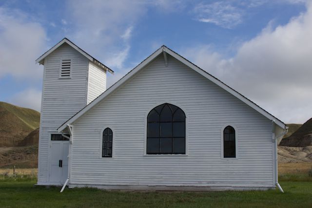
the Hoodoos as a “must see” and suggested we visit two restored churches in
Dorothy. She cautioned us about driving
in several areas because of clay roads being washed out or slick from the
extensive rain they had been receiving.
Our campsite was quiet… in fact, we appeared to be the only
ones there. Our campsite overlooked a lovely sandstone painted skirt.

The next morning we drove
out the famous Drumheller Hoodoo Park.
While small in stature, the community has certainly made the most of
their Hoodoos, including elaborate stairs all around the sandstone
structures. The information plaques were very informative, and the hoodoos interesting.


We continued our drive up to
Dorothy to visit their restored churches.
We decided to pass on the coal mining tour and dinosaur museum.

The next morning, we stopped by Lost Mountain to take their
driving tour. The information center had
warnings posted that the tour loop had several areas washed out due to the 2011
flood. We took part of the tour, not
finding many birds at all… most likely because we were in the middle of the day
when most of these birds are out gleaning other fields. We took a short hike up their grassland
trail, but the wind was fierce and cold, sending us back to the truck
early.
Campgrounds in the area were few and far between, so we
decided to travel onto the Quill Lakes, known for their abundant migratory waterfowl
and the main reason we had taken this path through Saskatchewan. Unfortunately, we chose to travel Highway 15
which was under major construction to make it into a heavy haul road. The continued rain had turned an eight-mile
section into the worst mud course we have run into… EVER! The mud was easily up to the running boards
in several places. Thank heavens for
four-wheel drive or we never would have made it through. What a mess! It took another trip to the car wash to clean the mud off the truck and camper so that we could remain fairly clean when getting in and out.
We drove into Wynnard and headed straight to their Waterfowl
Interpretive Center. While I hate to
leave our dear friends hanging, what we learned there is worthy of a post all
its own. So we leave you in suspense…
No comments:
Post a Comment