Sunday, September 12, 2010

Mile Marker Zero... Again


We are in Dawson Creek this afternoon.  On July 10, we began our journey up the Alaskan Highway.  We certainly didn't know what to expect... we were just ready for an adventure.  Nine weeks and 10,083 miles later, we can certainly say that we found one!

Our emotions fluctuate from remorse that it is over... to elation that we did it... to gratitude for the adventure that we have shared.  It feels more bittersweet than I can possibly express... certainly more so than either David or I expected.

Quite honestly, we are surprised to be here.  Between our time running short, R-2 needing maintenance, plus a promised visit to our friends at Kamparoo to get Ozzie checked out, we decided to forego traveling the Cassier Highway... for this trip.  (After all, we will need to travel at least a little new territory on our next trip up here!)  

It felt right to come back down the Alaskan Highway again.  We stopped at some familiar places along the road but were amazed at how different it all looked.  Many of the once-bustling lodges and tourist attractions are now closed.   Most of the seasonal workers have gone home.  The bright yellow fields of canola have been harvested.  At every turn, trees sport their autumn colors.  The wind has a definite chill.  As the season has changed from summer to fall, we, too feel changed by our own harvest of experiences.  

We looked at our MilePost yesterday and marked all the highways that we have traveled.  We have been up the Haul Road, Dempster, and Alaskan Highways from stem to stern.  We have traveled Alaska from Seward to Homer to Port Nikiski on the Kenai Peninsula, from Valdez to Fairbanks, from Skagway to Prudhoe Bay, from Wrangell-St. Elias National Park to Denali, and dozens of roads in between.  We have traveled the length of the Yukon and ventured into the Northwest Territory.  What a trip!  

Our camp looks like a small tent city this afternoon.  Our sleeping bags, mattress, and bedding hang on makeshift clotheslines and sapling trees.  With all the rain we have encountered, everything feels a bit damp and in need of a good airing.  Tomorrow we're off to Wetaskiwin for Ozzie's maintenance, then back to Edmonton for a little work on R-2.  

After that?  Long ago we learned that the end of one phase of any endeavor merely marks the beginning of another.  We have three or four weeks of travel left before arriving home.  Let the new journey begin!

Thursday, September 9, 2010

Skagway, Alaska


After a sunny morning's drive, we arrived in Skagway amidst misty rain.  Four cruise ships had docked in the harbor.  The streets bustled with tourists.  A server told us that as many as 10,000 tourists come into town each day by cruise ships, not including Skagway residents and those of us who travel by vehicle.  Needless to say, it was a shock to the senses to see so many people and shops!

We opted to stay nine miles out of town at the Dyea Campground, part of the Klondike Gold Rush National Historical Park.  Thankfully, our site was nestled in trees.  Only one other camper was staying in the campground.  

Steeped in history, this area is known as the launching point for so many stampeders during the 1898 Klondike Gold Rush.  Some came because they lusted for gold, others came distressed over hard economic times, still others came seeking adventure.  Few fulfilled these dreams, particularly when the harsh reality of Yukon winters caught many by surprise.

There is a haunting photo of Chilkoot Pass that we have seen along the gold rush trails.  

Stampeders at Chilkoot Pass (photo from Library of Congress).  For more information, see http://www.nps.gov/history/nr/twhp/wwwlps/lessons/55klondike/55klondike.htm 
The Royal Canadian Mounted Police, fearing that unprepared stampeders would die in the harsh winter, mandated that all stampeders must come with two month's supply of provisions, or 1,000 pounds of food, clothing, and gear.  The above photo was taken at Chilkoot Pass, during the 1898 gold rush frenzy.  Chilkoot Pass was the cheapest route between Alaska and the Yukon.  

Leaving Skagway, stampeders used the town of Dyea as their staging ground for the trip on the Chilkoot trail to Dawson City.  At 3,500 foot in altitude,  Chilkoot Pass became the juggernaut for many stampeders.  Each had to haul his provisions over the pass, an estimated 1,500 steps to the top.  Most lashed 100 pounds of gear on his back at a time and hiked up "the Golden Stairs," in lockstep behind yet another stampeder.  At the top, the provisions were registered.  Then the stampeder would slide back down the pass, pick up another 100 pounds of gear, and make the climb again.  Only when all of his provisions had reached the top was he allowed to continue his search for gold.

One report notes, "100,000 left for the Klondike," they say, "40,000 made it to Dawson City, and 4,000 found gold."  And probably 40 came away rich, if that many.  (See http://www.ralphmag.org/DO/klondike.html)

David and I discovered that the Chilkoot Pass trailhead was only a short distance from our campground.  Today, the trailhead is buried in a lush, almost tropical forest.  The initial ascent is steep and some 13 miles from Chilkoot Pass.  We only hiked for a short while along this 33-mile trek, with our thoughts on the original stampeder's journey.


We awakened the next morning to still more rain and decided that it was time to head due south.  After we crossed back into Canada, the clouds began to clear.


With the sun peaking across mountains bathed in gold, we felt we made the right decision.

For more information about the Chilkoot Trail and the Klondike Gold Rush, please visit http://www.nps.gov/history/nr/twhp/wwwlps/lessons/55klondike/55klondike.htm

Tuesday, September 7, 2010

Promises To Keep

With more than a tinge of sadness, we now leave the top of the world and the beauty that we have found here.  We must begin our journey south.  While we still have about a month left on the road, the time has come to begin our meandering towards home.  As Robert Frost so eloquently wrote in his poem, we have promises to keep.

Fall has come to northern Canada.  Aspen and poplar are ablaze in color.  The mountains sport a fresh dusting of snow on their peaks.  Another formation of geese flew overhead last evening, honking their farewell.  We know that we, too, must begin our migration south for the winter.  So we bid adieu to new friends, experiences, and top-of-the-world vistas. 

The woods are lovely, dark, and deep.
But I have promises to keep.
And miles to go before I sleep.


(From Robert Frost's poem, Stopping by Woods on a Snowy Evening.)

Saturday, September 4, 2010

Savoring the Dempster

After taking the Haul Road as far north as one can drive in Alaska, we were drawn to also take the Dempster.  This 456-mile-long gravel road runs north from Dawson City in the Yukon to Inuvick in Canada’s Northwest Territory. 
It was so rainy during our trip up the Haul Road that we were hardly able to enjoy our surroundings or even know much about them.  We expected barrenness on the Dempster, particularly above the Arctic Circle.  To our complete surprise, however, we encountered some of the most beautiful scenery of our entire trip.  Every turn seemed to offer a glimpse of God and His creation that, quite simply, amazed us.   

We began our trip up the Dempster with scattered sunshine.  As the day wore on, however, it began to mist, finally turning into a downpour.  We sludged along deep channels of mud, dodging potholes.
We spent our first night at the Engineer Creek campground.  After so much rain, the entire area was layered in black mud and puddles.  We found the driest site available and popped the camper open.  The rig was absolutely filthy.  Every time we touched it, we became caked in mud ourselves.  Our supper was ready-to-eat cheese, crackers, and other snacks.  We piled in the camper to stay as dry and clean as possible. 
As we chatted about the day, I spied movement in the alders behind our picnic bench.  Both David and I stood to see what it might be and were shocked to discover it was an enormous wolf.  The wolf ambled lightly among the aspens directly behind us.
His markings were unlike any I had ever seen, with silver bands layered across his back.  Grabbing the camera, I began snapping photos through the screen.  At one point, he looked directly at me, not with angst or anger.  In fact, as our eyes met, his seemed to soften.  It felt almost unbelievable to watch this remarkable animal walk less than 30 feet from the back of the camper.  Splendid God. 


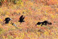
The next morning, we awoke to sunshine and left for Eagle Plains, our next stop on the Dempster.  Just above the Arctic Circle, we saw a dozen or more ravens darting over what looked like a huge boulder about 200 yards off the road.  We slowed and discovered that it was a large grizzly feeding in the tall grass, most likely off a downed caribou.
     The ravens tormented him… opportunists looking for an easy meal.  The bear would huff and run at them, scattering the birds for a short time.  Occasionally he would tip his nose to the wind, catching a scent.  At one point, he sat on his haunches.  Later, he rose on his back legs.  In amazement, we watched his antics for nearly a half hour.  Generous God.


We spent the night in Eagle Plains, opting for a cozy room and hot shower rather than another wet night in the camper.  After we had cleaned up, we took a drive to see what tomorrow's road had in store.  The sun came out from its hiding and reflected through the autumn leaves, enhancing their colors to an incomparable brilliance.  We strolled over a rocky hill to see the splendid horizon.  It felt wonderful to share this moment with a warm hand pressed in mine while a cold nose tipped the other.  Giving God.


We left for Fort McPherson the following morning.  Riding along Olgivie Ridge, we crossed into the Northwest Territory.  We stopped to see several herds of caribou across the valley.  Further up the road, a pickup passed us.  Hunters got out and headed towards two beautiful caribou bucks near a rock outcropping.  As I was setting up the tripod at the border crossing, rifle shots rang, and my heart stopped.  I closed my eyes, not willing to see one of these creatures downed… not today.  David scanned for the caribou with his binoculars.  We saw them both trot away.  I breathed a sigh of relief.  Merciful God. 


Around the next ridge, we saw another small herd of caribou, most still in velvet.

We crossed the cable ferry to Fort McPherson, a small community that sprung from a trading post during the gold rush between miners and First Nation inhabitants.  Today Fort McPherson offers a few vital services to Dempster travelers.  The majority in the community lives off the land.  We spoke with an elderly gentleman curious about our Texas tags.  He was the kind of man that beckoned with a wealth of stories and experiences.  Both David and I wanted to know more.  Too soon, we parted.  We set up camp at a territorial campground just outside Fort McPherson and, to our joy, discovered that the camp had hot showers.


The following day, another ferry crossing and a two-hour drive brought us to Inuvick, the furtherest north that one can drive in Canada until the ice roads are made to Tuk in January.  We found another great territorial campground with showers outside of town and settled in to enjoy Inuvick, its famous Igloo Catholic Church, and the First Nation Gwich-in culture.


We soon discovered that Inuvick, like all of the tranquil communities along the Dempster, lives to a special rhythm.  There’s no rush to begin work early.  Living off the land takes skills taught by one generation to another.  It requires knowing when caribou migrate and geese fly, what they eat, and where they live.  Lush forests, marshland, rivers, and streams provide nearly everything folks need here.  Abundant God.
We spent two nights visiting and hiking around Inuvick in misty rain with a few bursts of sunlight.  After one shower, a double rainbow appeared over our campsite.  Loving God.


Along our drive back to Eagle Plains, we watched a grizzly bear ravage berries along the roadside.  For nearly an hour, we hop scotched with four other cars to take photos of this magnificent creature.  He doused himself in a large puddle, and then strolled along beside us, almost as if on parade.  We were mesmerized.  Amazing God.


It rained nearly the entire way back to Tombstone Campground.  Occasionally, a bit of blue would appear in the sky.  Each time it did, the autumn colors would become brilliant once more.  By the time we set camp, the sun was out and the horizon became alive with color.  Glorious God.


We sit in a motel room this evening, savoring our time on the Dempster.  A simple but critical mechanical issue caused us to cut our trip short by two days.  It’s okay… we both know that we will return to the Dempster, God willing.  We have been smitten by it’s beauty and abundance and can’t wait to experience it again.
     The Haul Road is a working road, built specifically to bring goods to the Alaskan oil fields in Prudhoe Bay.  For that reason, people are discouraged from traveling it.  The Dempster connects people and communities.  As a result, Canada encourages folks to travel and enjoy it and the wonder of its animals and natural beauty... here at the top of the world.
We did not see the caribou migration that we expected.  Instead, our Surprising God showed us even better things.  We saw autumn in all of its splendor amidst beautiful mountain ranges and valleys, we met warm and caring people, we saw caribou and waterfowl gathering, and amazing animals in their natural habitat.
     Thank You, God.


Friday, August 27, 2010

Panning for Gold


We spent two nights at the Yukon River Campground, crossing the ferry into Dawson City to take in the sights.  


Dawson City is a town with a rich gold rush history.  In 1896, it grew from the hopes and heartaches of men planning to make it rich quickly.


We drove through the town and visited the museum.  Nearly a million tried to make it to the Yukon gold rush.  Less than 100,000 arrived, almost all too late.  We learned about fortunes made and mostly squandered.  We learned how the Royal Canadian Mounted Police patroled and kept the community from becoming lawless.

A drive outside of town reveals long, winding hills of tailings from the gold dredging, scars that will never heal.  It is a testament to the greed of man.  Dawson City barely survived the decline of many boom/bust towns.  It’s rich history, however, is now offering new gold in the form of tourism.

Tomorrow morning David and I leave to pan for our own gold, searching the horizon for signs of autumn.  We will travel 456 miles up the Dempster Highway, reaching all the way into Inuvik in the Northwest Territory.  

Thursday, August 26, 2010

Top of the World


Our original plan was to spend two nights in the Tok area before heading over the Top of the World highway.  Top of the World connects Chicken, Alaska, to Dawson City in the Yukon.  Dawson City was to be our staging area for taking the Dempster Highway into the Northwest Territory for (hopefully) viewing the caribou migration.

About the time that we left on our adventure to Alaska, rain washed out several places along Top of the World.  Several campers were stuck between the washouts for several days before repairs could be made to get them out.  We had read that the road was now open. 

When we arrived in Tok, however, we were greeted with the news that the road was still under repair.  In fact, the last convoy across Top of the World left in less than two hours.  If we did not make this convoy, the earliest we could go over the road would be on Sunday.  We hit the road immediately, hoping to make the 67-mile drive from Tok to Chicken in time.  If we drove around through Whitehorse, it would take over 700 miles rather than the 90-mile trip over Top of the World.

We made the convoy with only minutes to spare.  The pilot car led nearly a hundred cars and rigs across this narrow stretch of road.  We passed an enormous number of road crews, gravel trucks, and heavy equipment.  At one of the washout sites, we could see where the river had redirected itself to the opposite side of the road, taking the middle with it. 


Top of the World highway is aptly named.  Our dusty convoy traveled a ridge with breathtaking views into the Yukon and beyond.  A lonely border outpost rests at the Canada/US border.  The pilot car left us just before the border crossing. 


We said a brief goodbye to Alaska and headed to our campground this side of the Yukon River and Dawson City.


Wednesday, August 25, 2010

Over the Rainbow

From the Kenai Peninsula, we headed up the Tok Cutoff Road to the north side of Wrangell-St. Elias National Park.  We had visited the south side during our trip to Liberty Falls.  Now we entered the north side of this enormous national park.  Wrangell-St. Elias is the largest park in the nation.  The north side has very few amenities and is accessible only via Nabesna Road, a four-wheel drive trail.  The only campground located on the north side of the park is currently closed for construction.

We traveled to the end of the trail in between rain showers.  A water crossing proved fun, so David made a splash with the rig. 


We found a primitive campsite along Twin Lakes and set up camp.  A shower blew through, leaving us with a rainbow directly overhead.  It just doesn’t get any better than this!


That evening, the temperature dropped below freezing for the first time since we arrived in Alaska.  We awoke to sheets of ice sliding off the canvas.  Bundled up in just about every layer of clothing we could, we drove out of the park with a full view of Mount Wrangell.  What a beautiful sight!